Small to tiny run of westerly swell

Southern Tasmanian Surf Forecast by Craig Brokensha (issued Friday January 26th)
Best Days: Tomorrow, Sunday for the keen
Features of the Forecast (tl;dr)
- Small mid-period W/SW swell for later today, peaking tomorrow AM, with a smaller, reinforcing pulse for Sun AM
- Moderate NW tending stronger W/NW winds tomorrow, NW tending variable Sun
- Tiny Mon
- Tiny W/SW swell Tue through Thu with SW winds Tue AM, NW Wed and Thu AM
Recap
Tiny waves yesterday, while a low point in swell was seen this morning with near flat conditions.
A cold front moving through this afternoon is bringing an increase in weak W/SW swell but with windy, cross-shore conditions.
This weekend and next week (Jan 27 – Feb 2)
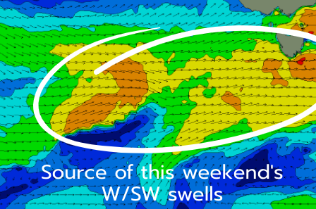
The coming period will be dominated by persistent frontal activity out of the west with it not being overly strong and also quite north in latitude, just within our western swell window.
This will result in mostly small pulses of swell in the 1-2ft range but with favourable conditions.
The current frontal system should generate a pulse of swell to 2ft tomorrow morning, easing back from slower 1-2ft on Sunday.
Winds look favourable all day tomorrow with a NW tending gusty W/NW breeze, NW tending variable on Sunday.
Tiny waves are due Monday and conditions look clean again in the morning ahead of a shallow, afternoon S/SW change.
The sources of W/SW swell for the rest of the week look a bit average, with a stream of W/NW winds not expected to generate anything in the way of size.
Expect mostly 1ft+ surf Tuesday through Thursday, possibly a little better late week but we'll review this on Monday. Have a great weekend!