Large swell for the weekend but with dicey winds

Southern Tasmanian Surf Forecast by Craig Brokensha (issued Friday November 17)
Best Days: Today, tomorrow morning, Sunday when winds go variable, Monday morning, Tuesday morning
Features of the Forecast (tl;dr)
- Easing surf tomorrow with W/NW tending S/SE winds
- Large S/SW groundswell for Sun AM, easing
- Light-moderate S/SE winds, tending variable then giving into strong sea breezes Sun
- Easing swell Mon with N/NW tending S winds late AM
- Reinforcing mid-period SW swell for Tue PM and Wed AM with N/NE tending S/SW winds Tue and strong SW winds Wed
- Small surf Thu with S/SW winds
Recap
The large swell seen mid-week eased back through yesterday from a small, peaky 1-2ft with less than ideal winds, while today some new energy has pulsed back to 2-3ft with a light offshore wind.
This weekend and next week (Nov 18 - 24)
Today's reinforcing swell pulse will ease into this afternoon and smaller tomorrow, but of greater importance is the large S/SW groundswell due across the state on Sunday.
A 'bombing' low has fired up south of the country, with a drop in central pressure over 24hPa within 24 hours. This is resulting in a great fetch of slow moving storm-force W/SW winds pushing east through our southern swell window.
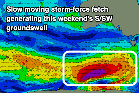
The end product will be a large, consistent long-period S/SW groundswell for Sunday, coming in bigger than the swell seen this week. Strong 6ft sets are due across Clifton at its peak in the morning, easing through the day and then down further from 3ft on Monday morning.
Winds are tricky for Sunday thanks to a trough lingering to our east, likely bringing morning S/SE winds that may tend variable ahead of stronger sea breezes.
Monday will be clean and better in the morning with a N/NW offshore before a trough brings a S'ly change late morning.
Looking at the rest of the week and some fun, reinforcing mid-period W/SW swell is due Tuesday afternoon and Wednesday morning but only to 2ft or so, with another pulse due later week.
Winds look favourable Tuesday morning and N/NE, but a cold front will bring a strong S/SW change into the afternoon, persisting from the SW on Wednesday and lingering out of the S/SW on Thursday. All in all it's a little dicey so make the most of the coming windows of clean conditions. Have a great weekend!