Upgrade in early next week's swell

Southern Tasmanian Surf Forecast by Craig Brokensha (issued Friday July 15th)
Best Days: Tomorrow, Sunday morning, Monday, Tuesday morning, Wednesday, Thursday
Features of the Forecast (tl;dr)
- Small W/SW swell tomorrow with strengthening N winds
- Easing W/SW swell Sun with NW tending W/NW winds
- Mod-large S/SW swell for Mon with strong SW tending S/SW winds
- Easing S/SW swell Tue with W/NW tending SW winds
- Easing surf Wed with NW tending variable E winds
- Reinforcing S/SW groundswell Thu with N tending variable E winds
Recap
Tiny yesterday with a small lift in swell today with light morning winds.
This weekend and next week (Jul 16 - 22)
Any small swell seen today will fade tomorrow, but a new, reinforcing W/SW swell is due tomorrow, generated by a weak polar front moving through our swell window yesterday.
This should provide 2ft sets across Clifton and strengthening N'ly winds will favour selected spots.
A drop from 1-2ft is due on Sunday with NW offshore winds, shifting W/NW ahead of a late, strong SW change.
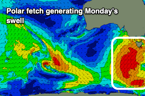 Now, we've got an upgrade in the frontal progression and cold outbreak due across the state on Sunday, with a great fetch of S/SW gales now forecast to be projected up into us, producing a moderate-large S/SW swell for Monday.
Clifton should come in around 4-6ft with strong SW tending S/SW winds, easing Tuesday with a morning W/NW breeze and solid 4ft sets, bumpy and with SW winds into the afternoon.
Wednesday looks nice and clean again with variable NW winds and a further drop in size from 2ft+.
One final trailing polar front firing up in our swell window early next week may generate a reinforcing 2-3ft of S/SW groundswell Thursday with favourable winds but we'll have a closer look at this Monday.
Following this the outlook is slow so make the most of the coming surf. Have a great weekend!