Small pulse of swell inbound but with average winds

Southern Tasmanian Surf Forecast by Craig Brokensha (issued Monday May 2nd)
Best Days: Tomorrow morning selected spots, Friday
Features of the Forecast (tl;dr)
- Inconsistent W/SW groundswell easing tomorrow with fresh N/NE-N winds
- Inconsistent W'ly swells building Wed PM with variable tending S/SW winds, easing Thu with fresh SW winds
- S/SE windswell Fri, easing later with N/NW winds
- Strengthening W/SW tending SW winds Sat with a new mid-period SW swell Sun but with SW winds
Recap
Tiny to flat conditions with no surf to really work with on the weekend, a touch bigger today and to 0.5-1ft with a tiny W'ly swell.
A new inconsistent W/SW groundswell should be providing better 2ft sets this afternoon as winds remain offshore with Cape Sorell buoy picking up the groundswell nicely.
Tim Bonython's Australian Surf Movie Festival is coming up real soon, with incredible new 8K footage of Nazaré, Jaws, Mavericks, Teahupo’o and more, that simply HAS to be seen on the big screen. Get your tickets to the Hobart show (Village Cinema) on Sat 7th May here: https://swllnt.com/3v2MlNc
This week and weekend (May 3 - 8)
This afternoon's inconsistent W/SW groundswell should ease back through tomorrow from 2ft on the sets across Clifton with a fresh N-N/NE breeze. This will favour some breaks over others.
 A temporary low point in swell is due Wednesday morning ahead of late increase in inconsistent W'ly groundswell, mixed in with some mid-period swell.
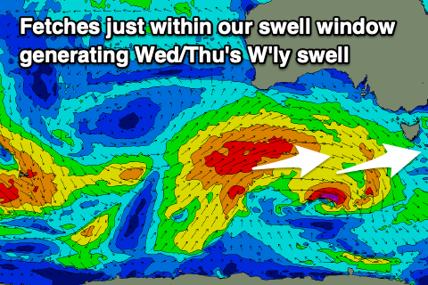
The source of these swells was a strong and very distant polar low firing up west of the Heard Island region, projecting east while generating a fetch of severe-gales.
The progression is now weakening while passing under Western Australia, generating a fetch just within our western swell window.
Owing to the distance and poor alignment, the swell will be very inconsistent but should build to 2ft+ later Wednesday, easing from a similar size on Thursday morning.
Locally winds should be variable Wednesday morning after an early morning trough moves through, freshening from the S/SW into the afternoon, spoiling the new swell. Winds unfortunately look to linger from the SW on Thursday as the swell eases, shifting from a strong, pre-dawn S/SE breeze to N/NW on Friday as a broad multi-centred low forms across Victoria and our state.
A brief infeed of strong S/SE winds Thursday evening should generate 1-2ft peaks Friday morning out of the S/SE, easing later in the day as the fetch retrogrades back to the west.
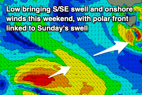 The swell will be tiny Saturday and it looks like the low will move back east, bringing strengthening W/SW tending S/SW winds as we fall under the influence of the backside of the low.
Swell wise there's no major size due from the low itself, but a new, mid-period SW swell is expected Sunday from a polar front pushing in this week, generating NW gales.
This swell should come in around 2ft but winds will persist from the SW on Sunday, improving Monday but with fading 1-2ft sets.
More on this in Wednesday's update though.