Long Wave Trough on the way

Southern Tasmania Surf Forecast by Craig Brokensha (issued Wednesday 13th January)
Best Days: Late Sunday, late Monday and Tuesday
Features of the Forecast (tl;dr)
- Long Wave Trough pushing east across us bringing building swells and mostly onshore winds Sat PM through early next week
Recap
Monday's tiny waves faded through yesterday leaving tiny to flat surf that's continued today.
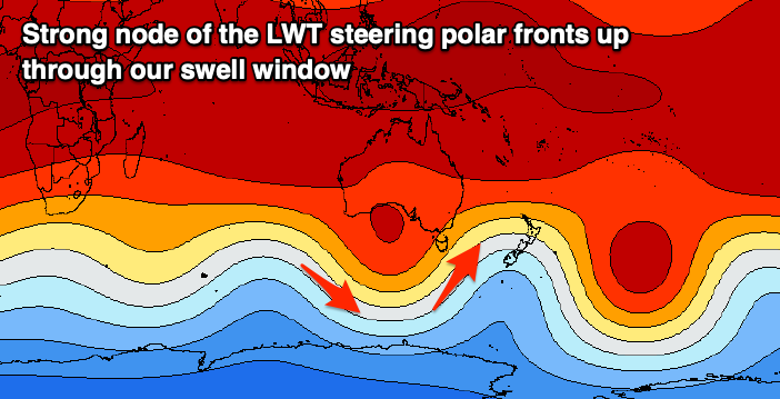
This week and weekend (Jan 14 - 17)
The end of the week doesn't hold much hope for any decent surf, but from the weekend we've got plenty of action across the Arm, as a strengthening node of the Long Wave Trough pushes in from the west and across us, stalling across New Zealand early next week.
This will steer the westerly stormy track up and past us from the weekend, with polar fronts due to project across us, bringing onshore winds but building surf, large into early next week.
So, the first of these fronts will track too north as the Long Wave Trough still sits west of us, with the front due to move through Friday, bringing nothing more than a late afternoon SW change.
Into Saturday the first more serious polar front is due to move up and across us, forming south of WA tomorrow evening, then projecting east-northeast while generating strong to at times gale-force W/SW tending SW winds, then pushing up across us through the day Saturday, and into early Sunday.
A building SW windswell is due Saturday afternoon ahead of the S/SW groundswell Sunday. Building sets to 3ft are due late in the day Saturday but with a strong SW breeze, peaking Sunday to 3-4ft as winds remain strong from the W/SW, tending possibly W/NW near dar as another front approaches.
This third system will be the strongest of them all with it due to deepen significantly south-west of us, projecting a fetch of gale to severe-gale SW winds through our southern swell window.
A large S/SW groundswell should build later Monday but peak Tuesday along with strong SW winds, though it's a bit too early to nail down the expected size. The one thing that's going for us is that both EC and GFS are holding strong, so check back Friday for the latest update on that's due next week.
Following this we may see some reinforcing S/SE groundswell from the backside of all this activity, but more on this Friday.