Strong SW groundswell tomorrow, easing into the weekend

Southern Tasmania Surf Forecast by Craig Brokensha (issued Wednesday 6th January)
Best Days: Selected locations tomorrow morning, Friday morning, Saturday morning, Sunday morning for beginners, Monday morning
Features of the Forecast (tl;dr)
- Strong SW groundswell peaking tomorrow morning with workable light W/SW tending S/SE winds
- Cleaner Fri AM with the easing swell
- Small clean waves Sat, Sun and Mon AM
Recap
Clean, fun 1-2ft waves yesterday, poor today with a change and we should see a strong kick in new SW groundswell later in the day.
This week and weekend (Jan 7 - 10)
This afternoon's strong kick in W/SW groundswell will peak tomorrow while tending more SW in direction, with the source of the swell being a strong polar low that moved through our swell window from the weekend into early this week.
A great fetch of severe-gale to storm-force W'ly winds were generated through our swell window and we should see strong 4-5ft sets across Clifton tomorrow morning, easing through the day, while a weaker trailing front that's currently south of us should keep 3ft sets hitting Clifton Friday morning, back to 1-2ft Saturday.
Now, the main issue are the local winds and we're looking at lingering, light to moderate W/SW-SW winds tomorrow morning, tending variable S/SE late morning before freshening with the sea breeze. So while not ideal there should be options to work the strong swell.
 Friday looks great with a light offshore N'ly wind ahead of strong S/SE sea breezes, similar Saturday.
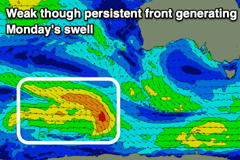
The swell looks to bottom out Sunday though with clean conditions, ideal for beginners, while some new inconsistent, mid-period W/SW swell is due Monday. The source of this is a good pre-frontal fetch of W/NW winds through our medium-range swell window, providing infrequent 1-2ft sets across Clifton Monday.
Conditions look clean most of the day ahead of a trough and S'ly change mid-afternoon.
Longer term there's nothing too significant on the cards as the storm track pushes slightly north but remains weak, generating mid-period W/SW swells. More on this Friday.