Large, west swell on the way

Southern Tasmania Surf Forecast by Craig Brokensha (issued Wednesday 25th November)
Best Days: Tomorrow afternoon for keen surfers, Friday until late afternoon, Saturday morning, Tuesday
Recap
Tiny surf to start yesterday ahead of a good pulse of new SW swell, which has eased back through this morning from a fun, clean 1-1.5ft on the sets.
This week and next (Nov 26 - Dec 4)
Into tomorrow we'll see a large, strong W/SW groundswell filling in across the state, generated by a significant low that formed south-west of Western Australia earlier this week.
When forecasting swells and surf, I'm mostly looking at forecast storms, fetches and tracks, but to verify that the storm reached the intensity indicated by the models there are a couple of satellites which measure the ocean surface roughness from high in the atmosphere.
This is then converted to give an observation of wind speed in the open ocean, which can then be compared to the forecast data.
Satellite observations of the current swell producing low have picked up a great signature of severe-gale W/SW-W/NW winds. This confirms the model forecasts and winds are actually if anything, a touch stronger than forecast.
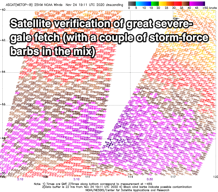
The only issue is that this fetch is in our western swell window, hence limiting the size potential from this source. The positive is that the low is still generating a great fetch of severe-gale W'ly winds in our swell window today, weakening into this evening before passing under us tomorrow.
As the low pushes under us tomorrow a better aligned fetch of weaker W/SW winds will be generated in our swell window, helping produce smaller, filler waves between sets.
The swell will likely be small and 1-2ft early, but a strong kick is due into the afternoon, reaching 3-4ft across Clifton late in the day. Friday should then see the swell easing back from the 3ft range, fading from 1-2ft Saturday.
Looking at the local winds tomorrow and before the swell hits, a fresh W-W/NW breeze is due, shifting SW later morning and then S/SW later in the day, creating average conditions.
Friday will be much better for selected locations with a N/NE offshore, holding until a late afternoon S/SW change moves through with a trough.
Conditions on the weekend are still a bit iffy but we should see a variable breeze Saturday morning before shifting onshore and then S/SE tending SW winds Sunday but tiny surf.
As talked about on Monday, a distant but strong polar low will form south-west of Western Australia, Friday, generating a fetch of W/SW gales. This low is then due to weaken and break up, with a weaker front pushing east towards us on the weekend.
A fun mix of W/SW groundswell and mid-period energy is due to build Tuesday, reaching 2ft+ into the afternoon, easing from a similar size Wednesday.
Conditions at this stage look favourable with a N/NE offshore Tuesday, but poor Wednesday with a strong W/SW change and possibly reinforcing swells for Thursday. We'll have a closer look at this in Friday's update though.