Slow weekend, new swells next week

Southern Tasmania Surf Forecast by Craig Brokensha (issued Wednesday 18th November)
Best Days: Tomorrow morning, Tuesday afternoon, Wednesday morning, possibly Friday morning
Recap
Our strong pulse of W/SW groundswell filled in yesterday, kicking to 3-4ft across Clifton through the day but options were limited with the wind and swell size.
Today the size has eased back to 2ft or so with a light onshore wind which is now strengthening in the wake of a surface trough.
This week and weekend (Nov 21 - 27)
The strong kick in swell seen yesterday, easing today was generated by a 'bombing low' and we'll see this swell continuing to ease in size over the weekend, fading from 1-2ft tomorrow, tiny Sunday.
Conditions will be clean each morning with a light N'ly, stronger E/NE into tomorrow afternoon with N/NW winds Sunday morning ahead of S/SE sea breezes.
The inconsistent, tiny swell for Monday is on track, generated by a weak frontal system developing behind the low earlier this week. No size above 1ft is due and conditions will be average with a lingering S/SW wind in the wake of a trough moving through Sunday evening.
We've now got a new swell for Tuesday afternoon with a small, tight low due to fire up south-west of us Sunday evening. A quick burst of W/SW gales is forecast, generating a fun spike of SW groundswell that should kick to 2-3ft by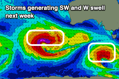 dark Tuesday, easing from 2ft Wednesday morning.
We'll see SE sea breezes Tuesday afternoon but Wednesday morning looks fun with a N/NW offshore before sea breezes kick in.
Longer term another strong low is forecast to develop south-west of Western Australia early next week and start north of our swell window but slowly move into it while pushing east-southeast.
A fun W/SW groundswell is due late week possibly reaching 2-3ft, but we'll have to review this Monday. Have a great weekend!