Upgrade in this week's incoming swell

Southern Tasmania Surf Forecast by Craig Brokensha (issued Monday 16th November)
Best Days: Thursday, Saturday morning
Recap
Tiny waves Saturday morning ahead of a small kick in S/SW swell through the afternoon from a weak mid-latitude low moving across us, easing Sunday from 1-1.5ft and then tiny today.
This week and weekend (Nov 17 - 22)
We've got more tiny to near flat surf due over the coming days ahead of an upgraded W/SW groundswell which now looks to produce some decent size.
Conditions will be clean both mornings with a W/NW breeze tomorrow and N'ly Wednesday ahead of sea breezes.
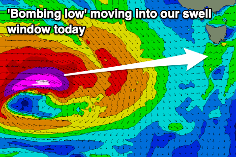 We then look to the strengthening mid-latitude storm to the south-west of WA, with a surface trough now dropping in pressure so rapidly that it'll be classified as a 'bombing low. That being dropping 24hPa of central pressure in less than 24 hours.
What this will result in is a stronger fetch of severe-gale to storm-force W'ly winds firing up in our western swell window, dipping east-southeast and into a better position while weakening slowly tomorrow.
The bonus will be the longevity of the low with it expected to continue generating swell until Wednesday afternoon.
We should see the long-period W/SW groundswell arriving through Thursday and building to a strong, straight 3ft on the sets later in the day. The longevity of the low will see the swell ease slowly, back from 2-3ft on Friday and down from 1-2ft on Saturday with tiny leftovers Sunday.
Conditions should be good Thursday with a N/NW tending variable breeze, giving into afternoon E/NE winds. Friday will become poor as a trough moves across us bringing a strong S/SW change around dawn.
The surf will clean back up into Saturday and Sunday as winds swing back offshore in the mornings.
Longer term a couple of tiny W/SW swells are on the cards for early next week but with no significant size. More on this in Wednesday's update.