Make the most of the coming swell

Southern Tasmania Surf Forecast by Craig Brokensha (issued Wednesday 4th November)
Best Days: Protected spots tomorrow, Friday, Sunday morning, Monday morning, Tuesday
Recap
Tiny waves the last two days, only suitable for beginners.
This week and weekend (Nov 5 - 8)
After the run of tiny surf, we've finally got some better swell on the way from tomorrow through next week.
Our first swell for tomorrow will be the least consistent, generated by an initially distant, slow moving polar low.
 While inconsistent the swell looks strong and should provide 2-3ft sets though winds look an issue and fresh from the W/SW-W tomorrow morning, SW into the afternoon.
A reinforcing pulse of more consistent SW swell is still on track for Friday and with better winds.
This is being generated by a polar front that's formed south of WA today, projecting a fetch of strong to near gale-force W/NW-W winds through our swell window today, weakening south of us tomorrow.
The swell should build into the afternoon and reach 3ft across Clifton, a touch smaller and to 2ft+ in the morning along with a N/NW tending W/NW breeze, stronger SW late afternoon.
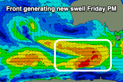
Behind this storm will be a similar strength but more elongated, drawn out and broader polar front, generating an even bigger SW swell for the weekend.
Unfortunately the front will bring that change later Friday which will persist Saturday with strong W/SW tending S/SW winds.
Size wise we should see surf to 3-4ft across Clifton Saturday, easing back from 3ft+ Sunday morning as winds improve and swing to the NW ahead of S/SE sea breezes.
The easing trend in surf through next week will be slow as follow up, weaker polar frontal activity produces, fun reinforcing swell pulses.
Monday looks to be around 2ft+ with clean conditions through the morning, smaller Tuesday under strong N/NE-NE winds.
Longer term there's nothing significant on the cards so make the most of the coming swells!