Great waves ahoy!

South Arm Surf Forecast by Ben Matson (issued Saturday 17th October)
Best Days: Sat: early variable/offshore winds, and a small, easing SW swell. Sun: fun pulse of new swell (peaking into the a'noon), generally light winds. Size easing Mon. Tues/Wed/Thurs/Fri: long period SW groundswells with generally light winds and sea breezes.
Recap: Thursday didn’t offer much surf, but Friday saw improving conditions and building swells, and an afternoon of fun surf conditions across the South Arm.
This weekend (Oct 17 - 18)
*This week’s Forecaster Notes will be a little erratic as Craig’s on annual leave*
A complex trough moving across Victoria on Saturday will probably only just influence Southern Tasmania’s wind regime. Fresh overnight (Friday) northerly winds will become variable through Saturday and persist into Sunday. There is a risk for periods of light to moderate onshores here and there but they shouldn’t become too strong and won’t last very long either.
As for surf, Friday’s new SW groundswell will ease through Saturday so the early session is your best chance for a wave, perhaps inconsistent 2-3ft sets early on, easing to 1-2ft throughout the day.
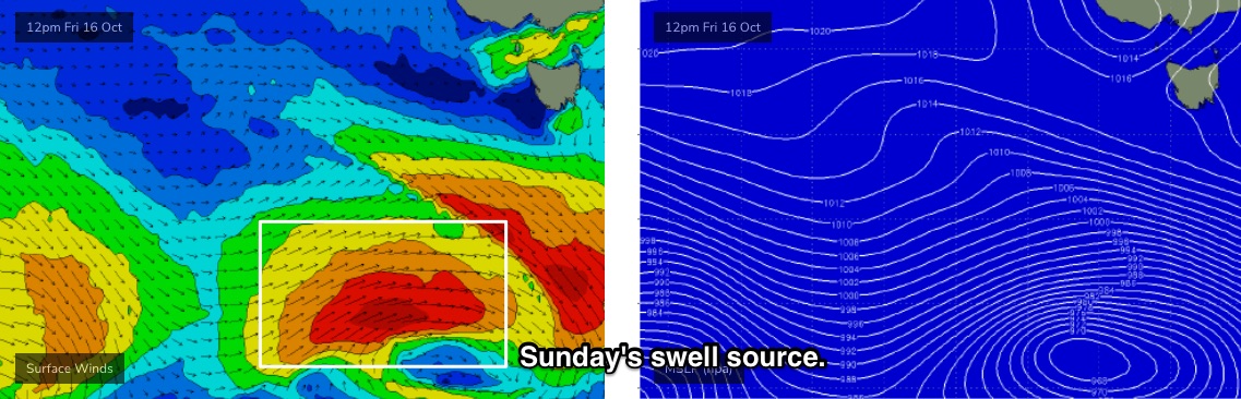
Sunday now has a little more promise for good waves. A polar low developing south of the continent over the last few days has been strengthened in the latest model run updates and it’s nicely aligned within our swell window (see below).
Early morning probably won’t show much sign of new energy but by mid-morning we should be on the upwards trend, and I’ve increased size projections to 3ft+ for the afternoon session across exposed beaches.
Passing fronts to the south could bring about a period of moderate W/SW winds but I reckon we’ll get through most of the afternoon without any major strength.
Next week (Oct 19 onwards)
We’ve got a good run of surf on the way. The main reason for this is a low latitude Southern Ocean storm track, which is positioned much more favourably within our swell window.
Sunday’s late SW swell will ease slowly through Monday and although there’s a lingering risk of W/SW winds, we should see variable conditions for the most part (especially early morning).
A series of powerful Southern Ocean lows in our far swell window are generating excellent long period swells that will arrive in succession from Monday evening onwards (leading edges Mon and Wed nights could be around 20+ seconds).
The latest model guidance has strengthened these systems a little more since Wednesday and also maintained their strength a little closer to the mainland, which will assist in maximising surf size potential throughout Tasmanian waters. The second swell in particular looks to be the biggest of the two.
However, the large travel distance will result in very inconsistent set waves. This will be most prominent on Tuesday and Wednesday, when the first groundswell will essentially be the only swell source in the water. On Thursday and Friday, the second long period groundswell will sit on top of decaying energy from the previous swell event, which (despite being smaller in size) will help to reduce the perceived inconsistency a little.
So, how big? At this stage I think we’ll see Tuesday building to 3-4ft across the South Arm swell magnets by the afternoon, possibly undersized early morning (expect flat spells of up to 15-20 mins between set waves). This swell should hold into Wednesday morning before easing through the day.
Thursday’s new swell should rebuild to 3-4ft at the South Arm’s swell magnets, though we may see the odd bigger set here and there. Size should persist into Friday morning then ease.
An unusually prolonged pattern of weak pressure across the region will create light winds most days, so conditions are looking to be very good. However, it’s worth noting that despite the size and strength of the swell energy, it's often the consistency (or lack thereof) that ultimately has the biggest influence on the quality of your session - even if the waves are great when they arrive, it's obviously harder to jag a set when they're extremely infrequent.
Have a great weekend, see you Monday!
Comments
Thermalben must've forgotten about our scheduled Forecaster Notes