Windy south followed by strong south-east

Southern Tasmania Surf Forecast by Craig Brokensha (issued Friday 25th September)
Best Days: Monday morning, Tuesday, Wednesday, Thursday
Recap
Peaky, workable waves to 2ft+ yesterday out of the S/SE, cleaner this morning but tiny and best for beginners.
This weekend and next week (Sep 26 – Oct 2)
As we move into the weekend we'll see a broad and cold low moving across us, drawing up a polar front behind it. This will bring strong SW winds tomorrow and a building S/SW swell into the afternoon, peaking Sunday.
 We should see Clifton build to a poor and windswelly 3ft late in the day, reaching 3-4ft on Sunday. Conditions will remain poor though with persistent and strong W/SW-SW winds.
A secondary pulse of reinforcing swell for Monday is looking decent, with a secondary polar front firing up on the tail of the initial system Sunday, generating strong to gale-force SW winds just within our swell window.
This should keep Clifton around 3ft into Monday afternoon, then easing from 2-3ft Tuesday.
Winds will slowly improve, swinging W/NW Monday morning before shifting SW late morning and then N/NW tending E/NE Tuesday.
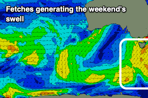
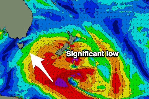 Longer term, the S/SE groundswell mentioned in Wednesday's update is on track, with a significant, broad and slow moving low due to form south of New Zealand early next week.
A fetch of gale to severe-gale S/SE winds will be generated just within our south-eastern swell window, with a S/SE groundswell due to fill in Wednesday and offer 3ft+ sets. Winds look to persist out of the N/NE, W/NW on Thursday as the swell eases from 2-3ft.
Exposed breaks to the south-east will be even bigger, but more on this Monday. Have a great weekend!