Poor tomorrow, then great

Southern Tasmania Surf Forecast by Craig Brokensha (issued Wednesday 16th September)
Best Days: Friday, Saturday, Sunday, Monday morning
Recap
A large new swell through tomorrow with favourable winds for protected spots, still solid and 3-4ft this morning with better conditions for more locations.
This week and weekend (Sep 17 - 20)
The swell event seen through yesterday and today will continue to slowly ease in size into tomorrow, dropping back from 2ft to possibly 3ft but the trough bringing strong S/SW winds is still on track, so conditions will be poor.
The swell is still due to bottom out Friday morning but quickly pick back up after that with a building new S/SW groundswell.
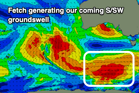 This swell has been upgraded since Monday with the polar fetch of W/NW tending W'ly gales on track and even patches of embedded severe-gale bursts.
This will produce a moderate sized S/SW groundswell that should build Friday and reach 3ft+ by dark, peaking Saturday morning to a strong 3-4ft. A drop in size is then due into the afternoon, easing to 2-3ft on Sunday. The swell is likely to hold this size through Sunday afternoon as a poorly aligned but additional fetch of NW gales push down through our swell window tomorrow and Friday.
We'll then see sets fading from 2ft on Monday.
Coming back to the local winds and we'll see Friday improve after Thursday's onshores with a N/NW offshore, giving into afternoon SE sea breezes.
Saturday will be clean at selected spots with a fresh N/NE tending E/NE breeze, holding out of the NE all day Sunday. Monday should see N/NE offshores, giving into a shallow change Tuesday.
Longer term a broad mid-latitude low moving in slowly from the west will have an infreed of E/SE winds across its southern flank and this may be our next source of swell, but more on this Friday.