Swell to continue this period

Southern Tasmania Surf Forecast by Craig Brokensha (issued Monday 14th September)
Best Days: Tuesday, Wednesday, Friday, Saturday, Sunday
Recap
Building surf on Saturday with a spike in new swell and light winds, solid into the afternoon. Sunday was smaller with the swell on the way out along with clean conditions.
Today we've got building levels of W/SW tending SW groundswell, 2-3ft this morning but more size should have been seen this afternoon.
This week and weekend (Sep 15 - 20)
The building SW groundswell due through today is expected to peak tomorrow morning, owing to the strongest front in the progression that's moved in from the west the last few days pushing in and under us today.
We should see Clifton peaking tomorrow morning out of the SW to 4-5ft+, easing slowly later in the day and then down further Wednesday from 3-4ft.
 The final front that was forecast to fire up on the tail of the progression now looks weaker but we'll still see 2ft to possibly 3ft sets Thursday morning, ahead of the swell bottoming out Friday morning.
Conditions tomorrow will be good all day with a NW tending W/NW breeze, N'ly Wednesday morning ahead of a shift to the W/NW early afternoon.
Thursday unfortunately looks poor as the trailing front clips us, bringing a gusty S'ly change, back offshore Friday morning but tiny.
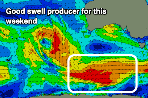
We've got some good S/SW groundswell on the way later in the week and more so the weekend from a polar front moving in under a high later this week.
A persistent and drawn out fetch of W/NW tending W'ly winds should kick up 2ft to possibly 3ft of swell later Friday, peaking Saturday to a good 3ft across Clifton with N'ly winds.
Following this the outlook goes a little funky with mid-latitude systems due to move in from the west which isn't ideal for us, but more on this Wednesday.