Fun surf days ahead before things slow down

Southern Tasmanian Forecast by Craig Brokensha (issued Friday 28th August)
Best Days: Saturday, Sunday morning, Tuesday
Recap
Small, clean, fun 1-2ft waves yesterday, while today we’ve got a new building W/SW-SW swell with solid sets and good winds for protected spots. The SW component should peak this afternoon to a good 4ft+.
This weekend and next week (Aug 29 - Sep 4)
We’ll see today’s mix of swells from the strong frontal system that pushed through last night easing fairly quickly tomorrow owing to the fast eastward and clearing nature of the front.
Behind it there’s a less favourable fetch of W/NW winds and this isn’t expected to generate any real additional size, with easing 2-3ft sets tomorrow morning, down to 1-2ft into the afternoon, easing from 1-2ft Sunday.
 Winds will be great tomorrow and N/NE tending N/NW, with stronger N/NE tending N/NW winds through Sunday.
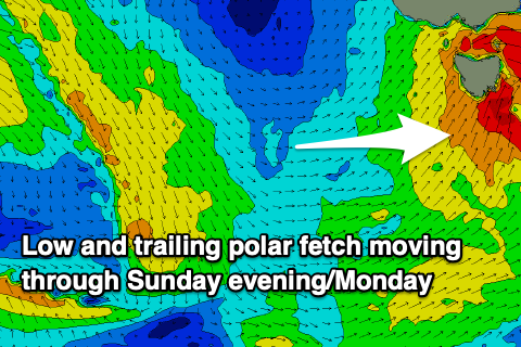
We then look to the mid-latitude low that’s forecast to move across us Sunday evening, bringing a strong onshore S/SW change and kick in S/SW swell Monday to 3ft+ or so. Unfortunately in the wake of the low conditions will be poor with the strong SW tending W/SW breeze, better Tuesday as winds revert back to the N/NW-N as the swell eases from 2ft.
Following this the storm track looks to focus up into the Indian Ocean, Western Australia and South Australia for the remainder of the week. This will be too north for us and in our western swell window, resulting in a run of small to tiny W/SW swells.
We’ll have a closer look at this on Monday. Have a great weekend!