Fun week of waves with swells of all sizes

Southern Tasmanian Forecast by Craig Brokensha (issued Monday 24th August)
Best Days: Tuesday morning, Wednesday, Thursday for beginners, Friday, Saturday, Sunday
Recap
The surf was a clean 2-3ft out of the S/SE Saturday morning, kicking later in the day with strong onshore winds as a broad low moved east and across us. Sunday morning was bigger and stormy to 3-5ft, easing through the day and back to 2-3ft with cleaner though still slightly bumpy conditions.
This week and weekend (Aug 25 - 30)
Conditions will be great tomorrow with the S/SE swell fully gone, replaced by a small mid-period S/SW swell from a weak polar front. This should keep the surf around 2ft and conditions look much better with a N/NW offshore, shifting W/SW through the day.
We’ll then see the sets holding 2ft Wednesday as a weak front passes under us tomorrow afternoon and evening, generating a fetch of strong W/SW winds. The swell will be more W/SW in direction and a morning NW breeze should only tend W/NW into the afternoon.
This swell will likely become tiny on Thursday with stronger N/NW offshores, best for beginners.
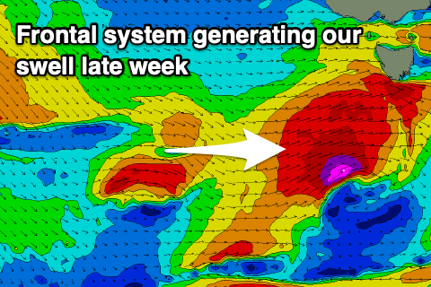 Moving into the end of the week and a strengthening cold front moving in from the west should generate a great fetch of gale to severe-gale W/SW winds directly south-west and then under us Thursday and early Friday.
A moderate sized W/SW tending SW groundswell is due, filling in Friday and coming in around 4ft or so under W/SW tending W/NW winds.
The swell looks to ease rapidly into Saturday with better offshores, followed by a possible reinforcing swell on Sunday.
The models are divergent on the follow up frontal systems but there’s plenty more swell on the cards, so check back here on Wednesday for the latest.