Slight delay and downgrade in SSE swell

Southern Tasmania Forecast by Craig Brokensha (issued Friday 21st August)
Best Days: Protected spots on the weekend, Tuesday morning
Recap
A tiny start yesterday morning but the new S/SE swell kicked in through the afternoon, with it clean and easing from a fun 2ft this morning.
This weekend and next week (Aug 22 - 28)
Unfortunately we've got another downgrade in the expected size out of the S/SE this weekend, with the low that's currently sitting to our west due to push slightly north and use up most of its energy before pushing slowly east tomorrow and across us into the afternoon and evening.
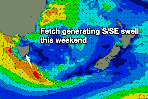 We'll still see a decent uptick in size across the South Arm very late tomorrow with early light SW winds due to swing strong S/SE into the afternoon. Size wise the morning looks 2-3ft or so, with a late on dark kick to 4-5ft if we're lucky.
Sunday morning will reveal the most size with 4-6ft sets, easing through the day along with S/SE tending SW winds.
Come Monday the swell looks smaller and easing from 2ft with a persistent W/SW breeze.
The W/SW wind will be linked to a weak polar front moving through, generating a pulse of SW swell for Tuesday to 2ft with better morning NW winds, shifting SW through the day.
Following this the surf looks mostly tiny, but we should see better activity Friday and next weekend as a conveyer belt of frontal systems move in from the west. More on this Monday though. Have a great weekend!
Comments
One day, just one day I would love an upgrade.