Large, stormy swell on the way

Southern Tasmania Surf Forecast by Craig Brokensha (issued Monday 17th August)
Best Days: Tomorrow beginners, later Thursday, Friday morning, the weekend in selected spots
Recap
Tiny, clean waves on Saturday with onshore winds kicking in yesterday with a building E/SE-SE swell, a little cleaner today though not ideal, better across more exposed spots to the east swell.
This week and weekend (Aug 18 - 23)
The current E/SE swell is expected to ease through tomorrow as winds improve, swinging N/NW, and then only N/NE through the afternoon. It'l be tiny though and only suitable for beginners.
The little fetch of strong S'ly winds expected to generate a reinforcing S'ly swell is now going to develop too far west tomorrow, but we'll see the fetch to our south-east developing Tuesday evening.
 This isn't as strong as forecast on Friday and will track slowly away from us, but with strong E/SE winds through our swell window for 18 hours or so we should see a fun pulse of S/SE swell building Thursday to 2-3ft across Clifton later in the day, easing from 2ft+ Friday.
Winds should be favourable Thursday and out of the W/NW tending NW and then NW tending stronger W on Friday as the swell eases.
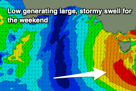
Moving into the weekend, and a low pressure centre forming south-west of us on Thursday will move east while deepening, directing a great fetch of strong to gale-force SE winds up and into us Saturday before moving slowly east Sunday.
This will generate a large and stormy S/SE swell for us Saturday, building to 6ft+ with strong to gale-force S'ly winds. Winds should swing back more SW on Sunday as the swell starts to ease from a still large 4-6ft and from a more SE direction.
Following this there's nothing too major on the cards but we've got a bit to work with in the meantime.