Fading surf ahead of new swells on the weekend

Southern Tasmania Surf Forecast by Craig Brokensha (issued Wednesday 8th April)
Best Days: Thursday morning, Saturday morning, Sunday morning, Monday morning
Recap
A solid kick in S/SW-S swell yesterday, easing back today with variable winds that are now sea breezey.
This week and weekend (Apr 9 - 12)
The surf will continue to ease over the coming days, back from a small 2ft on the sets tomorrow, tiny Friday. Conditions will be clean tomorrow morning ahead of sea breezes, all day offshore Friday.
 Moving into the weekend and we've got some model consensus on what's expected for our state.
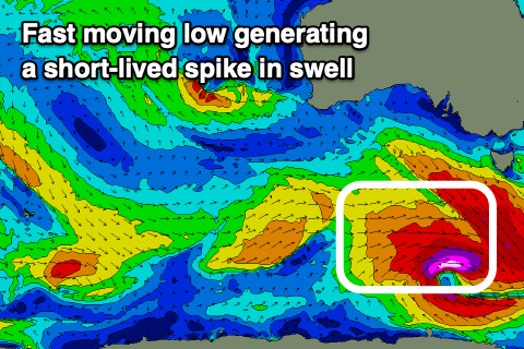
A strengthening polar low will develop south-west of us tomorrow evening, with a quick burst of gale to severe-gale and event briefly storm-force W/SW winds due to be generated in our south-western swell window.
A spike of new SW groundswell should be seen from this source on Saturday morning, coming in 2-3ft across Clifton but easing steadily through the day owing to the rapid movement east of the low.
Conditions look clean early with a W/NW-NW offshore, shifting strong SW early afternoon.
This change will be linked to a mid-latitude front moving across us, with a stronger polar front projecting a fetch of strong SW winds through our south-western swell window Saturday through Sunday morning.
A good reinforcing SW swell should be seen from this source on Sunday and Monday morning to 2-3ft or so, easing thereafter. Conditions look OK each morning but best Monday.
Longer term some new swell may be seen from the S/SE and then W/SW but at this stage to no major size. More on this Friday.