Southerly swell, unsure from the weekend

Southern Tasmania Surf Forecast by Craig Brokensha (issued Monday 6th April)
Best Days: Tuesday, Thursday
Recap
Tiny Saturday and Sunday morning with some new swell kicking later in the day and more so into today, coming in at 3ft out of the SW though not the cleanest.
This week and weekend (Apr 7 - 12)
We've got a good follow up S/SW groundswell due this afternoon and tomorrow across Clifton, generated by a fetch of S/SW gales forming around an embedded low at the base of the frontal progression, south of us.
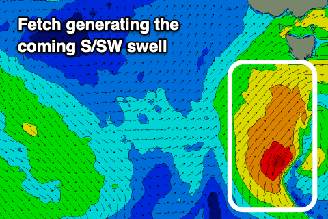 This low has moved further east but was still generating a good fetch this morning to our south and we should see solid 4ft+ sets across Clifton tomorrow, easing back from 3ft Wednesday morning and then 2ft on the sets Thursday owing to a final weak front moving through our swell window tomorrow.
Conditions tomorrow morning will be favourable with a W/NW-NW offshore, shifting SW-S/SW into the afternoon, with onshore SW winds all day Wednesday.
Thursday should then see N'ly offshores ahead of E/SE sea breezes, gusty N all day Friday.
Now, as touched on in Friday's update, a strong node of the Long Wave Trough forming across New Zealand will steer a series of strong polar fronts through our southern swell window from late this week and more so through the weekend and early next week.
The models diverge on this progression though with EC less favourable and GFS much more favourable. With this we'll have to have another look at the charts on Wednesday for a clearer idea on how the weekend and beyond are looking.