Good run of swell for the period

Southern Tasmania Surf Forecast by Craig Brokensha (issued Monday 23rd March)
Best Days: Tomorrow, Wednesday until early afternoon, Thursday morning, Friday, Saturday
Recap
Not the cleanest conditions but plenty of swell on Saturday to 2-3ft, while Sunday our stronger new groundswell filled in with building sets from 3ft+ in the morning with early W'ly winds.
Today was cleaner and around 3ft this morning but a change has since moved through along with a reinforcing SW groundswell.
This week and weekend (Mar 24 – 29)
The constant run of strong Southern Ocean fronts through our swell window and linked to the recent swells will continue over the coming days.
A reinforcing SW swell due on the coast today is expected to ease back in size tomorrow from a good 3ft or so with offshore N/NW winds and light E/SE sea breezes.
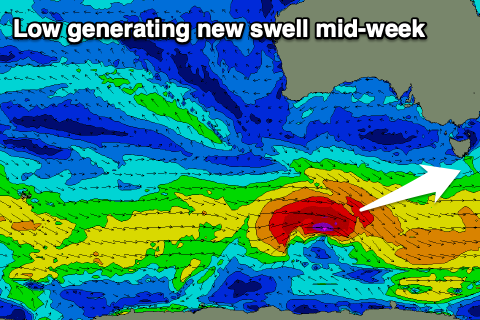 The new groundswell into Wednesday is still on track with it being generated by a strong low that's currently moving in from the west. A fetch of W/SW gales are moving through our western swell window, with the swell coming out of the W/SW and peaking into the afternoon to 3-4ft across Clifton.
Winds will be offshore from the NW early, but a SW change is due early-mid afternoon so try and surf later morning as the swell builds but ahead of the change.
Following this low there's plenty of weaker and persistent fronts moving through our swell window, producing fun levels of background swell from Saturday through next week.
Before this though, Wednesday's swell looks to ease from 3ft+ Thursday with a light morning W/NW tending NW breeze ahead of sea breezes, 2ft Friday with N/NW tending E/NE winds.
A slight kick in size to 2ft is due on Saturday with fresh N'ly winds, hitting a low point Sunday ahead of some new energy early next week. We'll have a closer look at this Wednesday though.