Lots of swell to sort through this period

Southern Tasmania Surf Forecast by Craig Brokensha (issued Friday 20th March)
Best Days: Tomorrow from late morning, protected spots Sunday and Monday morning, Tuesday morning, Wednesday morning
Recap
Tiny surf yesterday but our strong new groundswell for today has filled in with good conditions under an offshore NW breeze. Solid sets for experienced surfers.
This weekend and next week (Mar 21 - 27)
Today's strong spike in groundswell is due to ease back temporarily tomorrow ahead of a secondary strong SW groundswell on Sunday.
Unfortunately our onshore winds for tomorrow are still on track with a fresh S/SW breeze early, easing in strength during the day creating improving conditions. Size wise Clifton should ease back from 2-3ft.
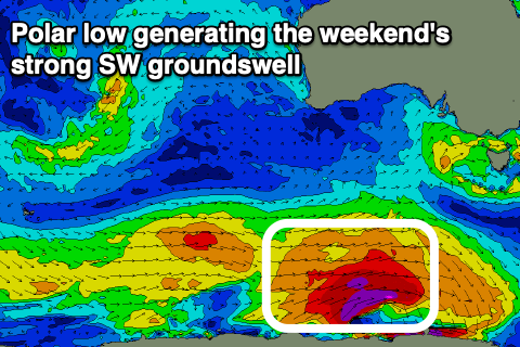
Looking at Sunday and the new long-period SW groundswell will be generated by a strong polar low that's formed under the country and is producing a great fetch of severe-gale to storm-force W/SW winds through our south-western swell window.
 We may see this swell kicking later tomorrow but come Sunday we should see strong 4ft waves, if not for the odd sneaky bigger one but with lingering W/SW winds, shifting stronger SW after early morning. Not ideal.
Monday is looking a touch cleaner with a W'ly breeze, again not ideal as the swell steadies at 3-4ft with a reinforcing SW swell from a secondary strong but weaker polar front moving in behind the current strong low.
Tuesday is looking the pick so far with NW tending variable winds ahead of weak sea breezes and easing 3ft+ sets.
One final pulse of swell is likely Wednesday as a strengthening and more northerly positioned low moves in from the west, generating a slightly more westerly swell, and at this stage surf to 3-4ft could be seen with morning NW offshores. We'll confirm this Monday but following this the outlook is quieter. Have a great weekend!