Great run of swell from late week

Southern Tasmania Surf Forecast by Craig Brokensha (issued Wednesday 18th March)
Best Days: Friday, dawn Sunday, Monday morning, Tuesday morning, Wednesday, Thursday morning
Recap
Small, clean and inconsistent waves yesterday, back to the tiny stuff today but ideal for beginners.
This week and next (Mar 19 - 27)
Tomorrow will remain tiny but our strong new S/SW groundswell into the end of the week is on track, as are the follow up swells through the weekend and early next week.
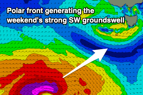
A strengthening node of the Long Wave Trough is moving in from the west, bringing with it strengthening polar frontal activity.
We're currently seeing a strengthening polar front south-west of us with a fetch of gale to severe-gale W/SW winds projecting ideally east-northeast through our swell window.
We may see a late spike in size tomorrow, with a peak due on Friday with strong sets to 4ft due across Clifton, easing Saturday from 2-3ft.
Winds look great Friday and offshore from the N/NW, tending variable early afternoon ahead of sea breezes. Unfortunately Saturday looks poor still with strong onshore S/SW winds and the easing swell.
 Moving into the weekend and we've got an upgrade in the SW groundswell due Sunday, with the polar low now looking stronger than forecast on Monday.
A great fetch of severe-gale to storm-force W/SW winds will be generated on the polar shelf, with the swell arriving overnight Saturday and peaking Sunday to 4ft or so again, if not for the rare bigger bomb but with a dawn W/NW tending SW breeze as a front clips the state.
Monday morning looks to offer a more prolonged W/NW breeze with a reinforcing SW groundswell to 3-4ft, easing slowly through Tuesday and Wednesday with morning offshores ahead of sea breezes.
Longer term the outlook goes quite so make the most of the current swells!