Very active period with large swells on the way

Southern Tasmania Surf Forecast by Craig Brokensha (issued Wednesday 26th February)
Best Days: Tomorrow morning, Friday, Saturday morning, Sunday morning
Recap
Fun and easing surf yesterday across Clifton, while today we've got building surf from a frontal progression moving in from the west, with onshore winds from dawn and the cold air bringing snow to the mountains.
This week and weekend (Feb 27 – Mar 1)
This afternoon's mix of building W/SW swells are due to ease back into tomorrow, likely to to 2ft on the sets across Clifton and only later in the day we may see some new mid-period W/SW energy. Winds will be great in the morning, fresh from the N/NW, tending W'ly mid-afternoon and W/SW later.
The mid-period W/SW swell due later tomorrow will be replaced by a larger W/SW groundswell, generated by a strong polar frontal progression that's currently moving in from the west.
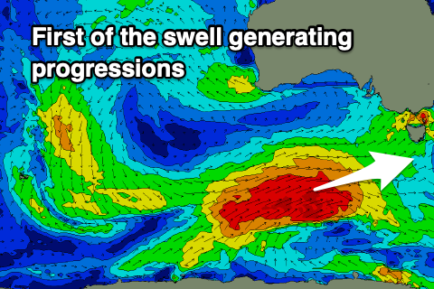 A great fetch of severe-gale W/SW winds have been generated through our western swell window since yesterday afternoon and through today, with the progression weakening while pushing up and across us tomorrow and then Friday morning.
Size wise we should see the groundswell peaking Friday to 4-5ft across Clifton, easing later in the day and then back from 3ft+ Saturday morning.
Winds on Friday should be out of the W/NW through the morning, possibly shifting W'ly for a period late morning and then back to the W/NW through the afternoon, with great N/NW winds Saturday morning ahead of S/SE sea breezes.
We've now got a secondary strong pulse of reinforcing swell due Sunday, generated by a strengthening trailing front behind the initial strong low.
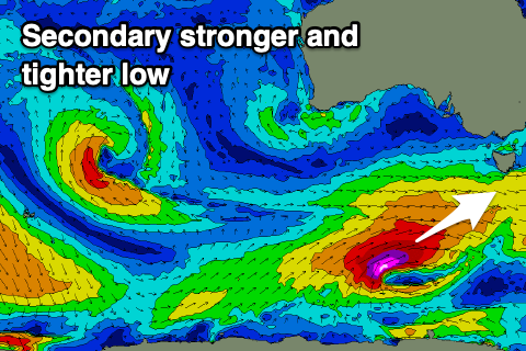 A fetch of severe-gale to storm-force W/SW winds will be generated directly south-west of us Friday and Saturday morning, producing a large long-period SW groundswell for Sunday morning.
Size wise we should see 5-6ft sets across Clifton and with N/NW winds ahead of S/SE sea breezes.
Monday looks suss as a trough moves in from the west bringing W/SW winds and an easing swell but longer term there's plenty more swell on the cards.
A slow moving and strong polar frontal progression will form south-west of us later in the weekend, producing a fetch of gale to severe-gale W/SW winds while slowly moving through our south-west and southern swell windows.
Another large SW tending S/SW groundswell event is due Tuesday/Wednesday, but more on this Friday.