Lots of swell activity this week

Southern Tasmania Surf Forecast by Craig Brokensha (issued Monday 24th February)
Best Days: Tomorrow morning, Thursday, Friday, Saturday, Sunday morning
Recap
A small fun swell on Saturday to 1-2ft, a touch tinier yesterday and to 1-1.5ft, back to 2ft again today with our new mix of W/SW swells.
This week and weekend (Feb 25 – Mar 1)
Today's mix of building W/SW swells are due to ease back tomorrow, easing from 2ft on the sets across Clifton and with an offshore N'ly ahead of an E/SE sea breeze.
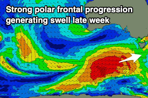
From Wednesday we'll start to see the first of our W/SW swells from a Southern Ocean frontal progression filling in.
This first swell will be west in nature and more mid-period, generated by a flurry of strong to gale-force W/NW-W/SW winds currently moving in from the west.
 The swell should build through Wednesday to 2ft into the afternoon but winds will be onshore and out of the W/SW-SW following a possible dawn N/NW breeze.
The swell will drop temporarily into Thursday but we'll see an increase in size through the afternoon ahead of a much stronger W/SW groundswell on Friday.
A tight and deep low forming south-east of the Heard Island region tomorrow will generate a fetch of severe-gale W/NW tending W/SW winds, broadening while projecting closer towards us and weakening just a touch.
This will move on top an active sea state, generating a large W/SW groundswell that'll peak Friday morning to 4-5ft or so across Clifton, with a late increase in size Thursday to to 3ft.
Winds will be offshore Thursday morning out of the N/NW, tending W'ly into the afternoon with W/NW tending W/SW winds Friday when the swell peaks.
Saturday will be great as the swell slowly easy under a N/NW offshore and easing 3ft+ sets, smaller again Sunday.
Longer term there's nothing too significant on the cards so make the most of the coming swells.