E/SE swell followed by a new S/SW

Southern Tasmania Surf Forecast by Craig Brokensha (issued Monday 17th February)
Best Days: Later Friday, early Saturday
Recap
Another poor weekend of surf, cleaner this morning but tiny and only suitable for beginners.
This week and weekend (Feb 18 - 21)
Tomorrow morning will start tiny, but into the afternoon a new pulse of E/SE groundswell is due, with a peak expected on Wednesday morning.
The source of this funky and tricky swell is the remnants of Tropical Cyclone Uesi, with it deepening off the South Island of New Zealand last night and early this morning, generating a burst of E/SE gales.
This is just within the South Arm's swell window but with less swell shadowing to the east compared to west, we should see some sets pushing in for the South Arm, reaching 2ft later Tuesday and peaking Wednesday morning to 2ft+.
 Unfortunately winds are still looking poor and out of the S/SE on Tuesday afternoon with sea breezes, strong S/SE on Wednesday as a broad low moves across us.
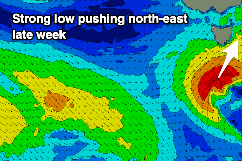
Come Thursday onshore S/SW winds will persist as a small low moves in from the south-west.
This system has only recently appeared on the charts and it'll deepen on approach, generating a fetch of strong to gale-force SW winds while projecting up past our south-western swell window.
A moderate to large spike of S/SW swell, building Friday and reaching 4-5ft later in the day, easing rapidly Saturday from 3ft+ or so.
Winds will be onshore and strong from the W/SW tending SW as the low pushes north-east, back to the W/NW on Saturday morning as the swell eases.
Longer term there's some small new W/SW swell on the cards for next week though the models are a bit divergent regarding the polar storms coming in from the west, so check back here on Wednesday for a clearer idea.