Plenty of surf all week, large one day

Southern Tasmania Surf Forecast by Craig Brokensha (issued Monday 3rd February)
Best Days: Tomorrow morning, Wednesday morning, Thursday, Friday morning
Recap
Nothing to surf over the weekend and tiny and bumpy today.
This week and weekend (Feb 4 - 9)
A mix of weak SW windswell and new S/SE groundswell are due across Clifton tomorrow, the first generated by a cold front moving across us today. Don't expect much over 1-2ft from this source.
The S/SE groundswell generated by a stationary fetch of strong to gale-force S/SE winds south of New Zealand since late last week and through Saturday is still expected tomorrow and Wednesday.
 Sets to an inconsistent 3ft are due across Clifton tomorrow and Wednesday, easing through Thursday.
A W/NW breeze is due tomorrow morning, shifting W/SW later morning and then S/SW, with NW winds ahead of SE sea breezes Wednesday.
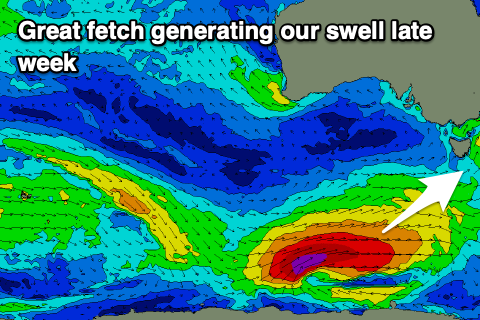
Moving into Thursday and our good new S/SW groundswell is now looking larger and stronger with an upgrade in the polar low generating it.
The low is forming south of WA and we'll see a great fetch of gale to severe-gale W/SW winds projected through our south-west and then southern swell window.
A late pulse of size is likely Wednesday ahead of a peak Thursday morning to 4-5ft across Clifton, easing into the afternoon, down from 2-3ft Friday.
Winds look favourable and offshore from the N/NE through the morning ahead of E'ly sea breezes Thursday, variable Friday morning though shifting onshore with a trough and S'ly into the afternoon.
Beyond this there's nothing significant at all on the cards though the East Coast will be smashed by swell, so check out their Forecaster Notes this evening.