S/SE swells for next week

Southern Tasmania Surf Forecast by Craig Brokensha (issued Wednesday 29th January)
Best Days: Monday morning, Tuesday morning, Wednesday morning
Recap
The stronger pulse of W/SW groundswell for yesterday morning came in at a good 2-3ft across Clifton with great conditions, easing into the afternoon with favourable winds most of the day. Today is smaller but clean again and 1-2ft, with the swell on the way out.
This week and weekend (Jan 30 – Feb 2)
I hope you made the most of yesterday and this morning as the coming outlook isn't too crash hot at all.
There's no decent swell due over the coming days or weekend, and moving into early next week, a couple of weak mid-latitude fronts pushing in from the west look too far north to generate any major size.
 Sets to 1-2ft may be seen late Sunday but with W'ly winds, 1-2ft Monday with W'ly tending SW winds.
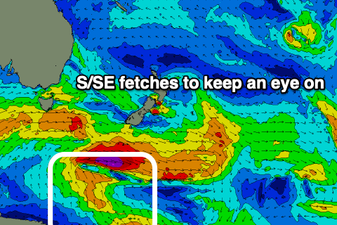
This swell will fade through Tuesday but the S/SE groundswell pointed out last update looks to fill in.
The source of this swell which looks to last a good three days is an anchored fetch of strong to gale-force S/SE winds due to be generated through our swell window from tomorrow afternoon and evening through Monday, south of New Zealand. It'll have various ebbs and flows, with inconsistent amounts of S/SE swell due to arrive later Monday but fill in more so Tuesday through Wednesday.
Size wise we're probably looking at sets around 3ft or so, but we'll have a closer look at this Friday.
Winds on Tuesday will shift onshore in the wake of a trough moving across us, possibly W/NW early, variable Wednesday morning ahead of sea breezes and the NE to E as the swell eases. Check back here on Friday for more on this though.