Stacks of wind, plenty of surf

South Arm Surf Forecast by Ben Matson (issued Friday 18th October)
Best Days: Sat PM/Sun: solid building surf, but very windy at times. Mon: strong though easing swell with gradually abating winds. Wed PM/Thurs: building long range swells, super inconsistent but with pockets of good winds.
Recap: It’s been really small and clean for the last few days.
This weekend (Oct 18 - 19)
The publish time of these Forecaster Notes will be erratic this week, as Craig’s on annual leave. To receive an email when they go live, please edit your user settings here: www.swellnet.com/user
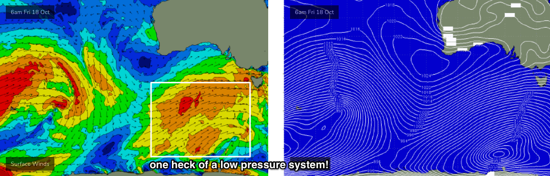
Gale force westerly winds are expected across exposed coasts for much of the weekend. We’ll see pockets of lighter W/NW winds at times but on the balance it’s going to be pretty blustery.
As for surf, we’re still looking at solid swell event building steadily through Saturday, peaking overnight or perhaps early Sunday morning and then trending down late Sunday afternoon.
The source of this swell is a very strong, broad cold front and associated polar low (and another strong system preceding this, earlier in the week), of which satellite data now shows core winds within the polar low were slightly under that predicted by the models all week. Whilst I still think we’ll see peak surf size reaching 4-6ft at exposed South Arm locations on Sunday, protected spots (handling the wind) will be significantly smaller. Expect much smaller surf early Saturday ahead of the upwards trend.
Next week (Oct 20 onwards)
A high pressure ridge will move in from the west during Monday, gradually weakening the pressure gradient and slowly relaxing wind speeds - though it’ll remain gusty W/NW thru’ W’ly at times in the morning.
Wave heights will also ease, from 3-4ft to 2-3ft during the day and then maintain small surf in the 2ft+ range through Tuesday and Wednesday, courtesy of a small polar low developing at the tail end of the current fetch (over the weekend, S/SW of the state). Moderate W/NW tending W’ly winds are expected Tues/Wed so conditions may be a little iffy but there’ll be workable options.
On Wednesday, the leading edge of a new groundswell will make landfall.
It’s being generated by a powerful, unusually stationary low and front in the central/southern Indian Ocean (near Heard Island) which is expected to remain in the same position for the next few days - this doesn’t happen very often in this part of the world. It’s also a shame it’s positioned so far from our coast as we’ll see a significant size loss by the time it reaches Tasmania longitudes, and therefore the sets will be very infrequent. The fetch is also much better aimed towards Indo and WA than Tasmania so we'll see smaller sideband energy thank other regions in the direct firing line.
This swell should slowly build super-inconsistent W/SW groundswells from Wednesday into Thursday, into the 2ft+ range across the South Arm. Expect extremely long breaks between setsas it'll lose a lot of size bending efficiently into Storm Bay.
The swell will probably maintain size into Friday but an unrelated deepening cut-off low approaching from the west will bring about a renewal of windy NW conditions throughout the day, swinging to the W at strength on Saturday and rapidly building local swells.
More on this in Monday’s update. Have a great weekend!