Rare E/SE swell for the weekend but the winds..

Southern Tasmania Surf Forecast by Craig Brokensha (issued Friday 11th October)
Best Days: Wednesday and Thursday
Recap
Average winds spoiling conditions across Clifton the last couple of days with some fun swell.
This weekend and next week (Oct 12 - 18)
These notes will be brief as Ben's on annual leave.
The swell direction will swing from SW to E/SE tomorrow as today's swell fades and a new E/SE swell fills in from a strong Tasman Low that's been sitting off New Zealand's South Island since yesterday.
A great fetch of strong to gale-force SE winds have been aimed in our swell window, generating a large swell for the East Coast, but we should see 1-2ft sets tomorrow and Sunday, fading Monday.
 More exposed breaks to the east down the South Arm should see more size but winds are the problem.
E/NE winds are due all tomorrow, N/NE tending stronger E/NE on Sunday.
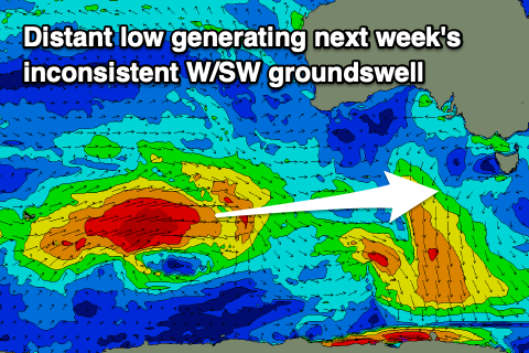
Following this there's nothing significant due until Wednesday. We've got a slight upgrade in an inconsistent W/SW groundswell due, with some reinforcing mid-period energy behind it.
A strong polar low has formed around the Heard Island region and will push east over the coming days, generating a fetch of severe-gale W/SW winds in our western swell window.
The storm will weaken south of WA but continue east, producing strong W/SW winds in our swell window.
Only a small and inconsistent 1-2ft wave is due Wednesday and Thursday with offshore winds. More on this and stronger follow up activity for next weekend on Monday. Have a great weekend!