Swell for the coming days but winds are average

Southern Tasmania Surf Forecast by Craig Brokensha (issued Wednesday 9th October)
Best Days: No good days
Recap
Tiny onshore surf yesterday, not much chop into today either and best for beginners.
This week and weekend (Oct 10 - 13)
These notes will be brief as Ben's on annual leave.
 Later today a good pulse of SW groundswell is due, generated by a strong polar low the last couple of days.
Sets to 3ft are due on dark today, easing back from a similar size tomorrow morning but winds are still looking onshore from the W/SW tending S/SE. Friday then looks poor with SE winds and a further drop in size from 1-2ft.
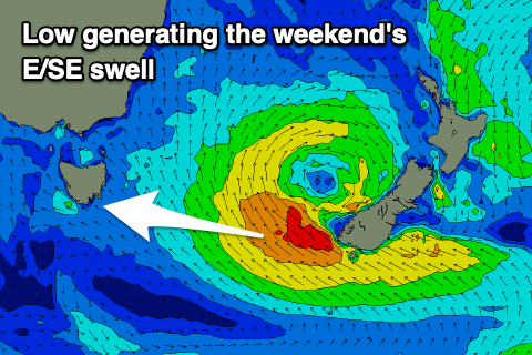
Our small E/SE swell for the weekend is still on track, with a Tasman Low due to drift south-east and stall off New Zealand's South Island.
A broad and persistent fetch of strong E/SE winds will be generated in our eastern swell window from tomorrow through Friday. This will generate a great E/SE swell for the East Coast, with Clifton possibly seeing 1-2ft sets, bigger down the South Arm but with unfavourable E/NE winds Saturday, better though still not great N/NE tending E/NE winds Sunday.
Following this there's nothing significant on the cards, so maybe check the East Coast forecast for more options.