Not the best weekend, large swells next week

Southern Tasmania Surf Forecast by Craig Brokensha (issued Friday 13th September)
Best Days: Saturday morning keen surfers, Tuesday, Wednesday, Thursday, Friday
Recap
Another solid but W/SW groundswell for yesterday to 3-4ft but with less than ideal conditions, easing back from 2-3ft this morning with lighter winds.
Today’s Forecaster Notes are brought to you by Rip Curl
This weekend and next week (Sep 14 - 20)
We're looking at smaller surf into the weekend with dropping sets from the 2ft range tomorrow morning and conditions look dicey with a W-W/SW breeze, more onshore through the day.
Sunday will start tiny, but a new mix of inconsistent W/SW groundswells are due to build into the afternoon, ahead of a larger SW groundswell Monday, easing Tuesday.
A deepening pre-frontal fetch of severe-gale to storm-force W/NW winds drifting east-southeast and into our swell window this evening will continue tomorrow morning, stalling south-west of us on Sunday and continuing to aim a fetch of W/SW gales in our south-western swell window. The system will then project slowly north-east towards the Tasman Sea on Monday, keeping wave heights solid into Tuesday morning.
We may see 2-3ft waves later Sunday from a fetch of W/SW gales moving through our western swell window Saturday, along with a N'ly tending S/SE breeze, larger Monday and to the 4ft range but strong W/SW tending SW winds with the passing progression.
Tuesday looks great as winds swing back to the N/NW (tending W/NW into the afternoon) along with an easing SW swell from 3ft+.
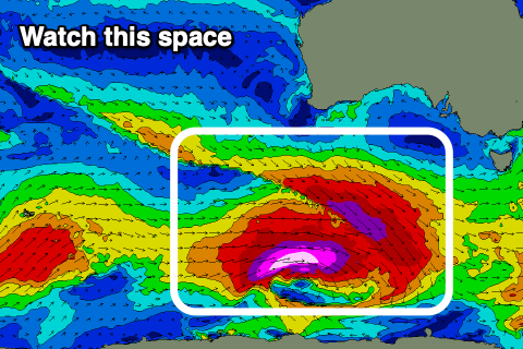 Of greater importance is a very significant polar storm forming in the wake of the weekend's and early next week's activity.
This storm will develop south-west of WA on Sunday, with a pre-frontal fetch of severe-gale W/NW winds priming the sea state for a post-frontal fetch of storm-force W/SW winds, tracking east along the polar shelf through our south-western swell window before passing under Tassie on Tuesday.
This is quite a significant storm and a large, long-period and powerful SW groundswell will be generated, building strongly Wednesday afternoon and likely peaking under the cover of darkness, easing slowly Thursday.
Size wise, Clifton should build Wednesday to 4-6ft by dark with fresh N tending E winds, easing from 3-5ft Thursday with gusty N/NE winds.
We'll take a closer look at the timing, size and local conditions regarding this swell on Monday.
Following this the storm track looks to shift a little north of us, but more on this Monday. Have a great weekend!