Overactive period of surf ahead

Southern Tasmania Surf Forecast by Craig Brokensha (issued Wednesday 11th September)
Best Days: Early Thursday, Friday, later Sunday, next week
Recap
Fun, clean waves yesterday with a mix of swells to 2ft, much better today with a strong new W/SW tending SW groundswell to 3-4ft with offshore winds.
Today’s Forecaster Notes are brought to you by Rip Curl
This week and weekend (Sep 12 - 15)
Today's swell was the first of two from back to back lows drifting in from the west this week.
The secondary low was a little stronger than forecast on Monday but west in direction, with it peaking tomorrow to a similar 3-4ft across Clifton, but a little less consistent and with a wider variety of size with the west direction.
Winds are only looking favourable for a short period early with a dawn N/NW breeze, shifting W/SW mid-morning.
This will be related to a secondary weaker front moving through, producing a reinforcing W/SW swell for Friday morning to the 3ft range across Clifton, easing through the day.
Yet another weaker front moving through Friday evening looks to produce a close-range SW swell to 2ft+ Saturday morning, easing through the day.
Winds should hold out of the N/NW-N most of the day Friday creating great conditions, W/SW-S Saturday.
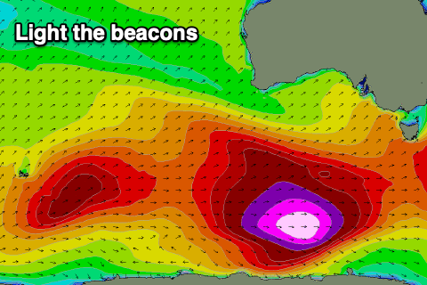 Looking from Sunday onwards, and it looks like the Southern Ocean is going to fire up in a big way, possibly owing to the Sudden Stratospheric Warming event we've been discussing.
Back to back strengthening storms are forecast to form in our swell window, the first dipping east-southeast and to a positioned south-west of us on Saturday, stalling and aiming a fetch of gale to severe-gale W/SW winds in our swell window, followed by another more elongated storm early next week.
Large, long-period groundswell energy is due from later Sunday through most of next week with what looks to be favourable winds as the storms stay south. More on this Friday though.