Good swell over the coming days with varying winds

Southern Tasmania Surf Forecast by Craig Brokensha (issued Monday 17th June)
Best Days: Tuesday morning, Thursday morning, Sunday morning
Recap
A good increase in new swell Saturday but not the cleanest, much better Sunday with a proper offshore and good easing 2-3ft sets. Today the swell was back to 1-1.5ft but clean again.
Today’s Forecaster Notes are brought to you by Rip Curl
This week and weekend (Jun 18 - 23)
As discussed in this forum thread here, the wave model data is incorrect for the coming few days owing to an update we did over the weekend. With the model starting from scratch, the swells due tomorrow and Wednesday which were generated mostly before the restart are not showing on the charts.
There's been no real change to Friday's forecast for tomorrow's initial pulse of long-period W/SW groundswell, and then the follow up and slightly larger W/SW groundswell on Wednesday.
We should see Clifton coming in at a strong but inconsistent 3ft tomorrow morning as the first swell peaks, while the secondary swell may come in a touch bigger Wednesday morning to 3ft to occasionally 4ft.
Winds will be good tomorrow morning and N tending N/NW, but giving into a W/SW-SW change early afternoon.
 Wednesday unfortunately looks to see onshore W/SW winds persisting, creating average conditions.
Thursday morning looks clean again with a NW tending W/NW breeze ahead of a SW change early afternoon. Clifton should still be 2ft to maybe 3ft and fun before becoming tiny Friday.
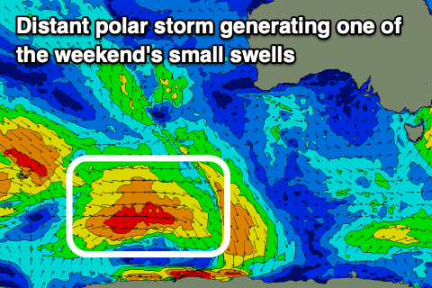
Into the weekend small and inconsistent pulses of W/SW and SW groundswell are due off firstly a very distant but strong polar low and then weaker fetches of W'ly winds on the polar shelf, closer to us later this week.
We should see an inconsistent increase in size Saturday afternoon to 1-2ft but more so Sunday though onshore winds look to persist on Saturday, back to the NW Sunday morning.
Longer term we may see a stronger polar front developing south of us on the weekend generating a strong S/SW groundswell for early next week, but we'll have a closer look at this Wednesday.