Good clean swells over the coming period, windier and larger next week

Southern Tasmania Surf Forecast by Craig Brokensha (issued Monday 20th May)
Best Days: Every day this period besides Thursday
Recap
Nice fun 2-3ft waves on Saturday morning with a new pulse of W/SW swell, a touch smaller and back to 2ft yesterday morning.
Today a new S/SW groundswell seen later yesterday has boosted waves back to 2-3ft this morning with a light offshore wind.
Today’s Forecaster Notes are brought to you by Rip Curl
This week and weekend (May 21 - 26)
A secondary increase in S/SW groundswell should be showing on the coast late today, generated by a significant fetch of severe-gale to storm-force W/NW winds along the polar shelf over the weekend.
The front was stronger than forecast and I'd expect wave heights to reach 3-4ft later today, with a drop due tomorrow from 3ft tomorrow morning, smaller and 1-2ft Wednesday morning.
 Winds will be great and offshore from the W/NW-NW most of tomorrow, similar Wednesday.
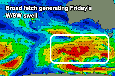
We'll see the swell bottom out into Thursday morning ahead of some new W/SW groundswell building later in the day but more so Friday and Saturday.
A strong and slow moving front that's currently south-west of WA, north of our swell window, will dip south-east and into our western swell window tomorrow afternoon.
A fetch of strong to gale-force W/SW winds will be aimed through our western swell window, followed by a closer and more southern (in latitude) fetch of W'ly winds Wednesday evening and Thursday.
At this stage we're looking at surf to 2-3ft on Friday from a fairly western direction, swinging more SW Saturday while easing from 2-3ft. Winds look great and from the W/NW Friday, N/NW Saturday.
Longer term we've got larger and windier swells on the cards as a node of the Long Wave Trough moves in from the west, bringing with it a flurry of strong and prolonged storm activity. More on this in Wednesday's update.