The swell tap keeps running

Southern Tasmania Surf Forecast by Craig Brokensha (issued Friday 17th May)
Best Days: Every day this period
Recap
Persistent levels of swell the last few days from a mix of sources, 2-3ft both yesterday and this morning with favourable winds.
Today’s Forecaster Notes are brought to you by Rip Curl
This weekend and next week (May 18 - 24)
Yet another pulse of W/SW swell is due tomorrow morning, generated by a low moving in from the west yesterday and under us today.
 Sets to 2-3ft are due across Clifton and winds will be good through the morning and offshore from the W/NW-NW, giving into a SW change midday or so.
Sunday morning looks to be a low point, though not dropping below 2ft across Clifton ahead of new S/SW groundswell pulses into the afternoon and later Monday/Tuesday morning.
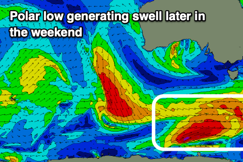
The first pulse will be produced by a good strengthening polar low south-west of us today, producing a broad fetch of W/SW gales.
We should see an afternoon increase in size Sunday, building to 3ft to occasionally 4ft across Clifton, easing back from 3ft+ Monday morning.
A secondary stronger though faster moving low should produce a secondary pulse of S/SW groundswell for Monday afternoon, keeping 3ft sets hitting the coast, easing from 2-3ft Tuesday morning.
Winds through this period look great with Sunday afternoon seeing weak sea breezes, better Monday with a N/NW tending N/NE breeze. Tuesday should then persistent NW winds, variable into the afternoon.
Longer term we're looking at an active period into the end of the week and beyond as the westerly storm track fires up to our west. More on this Monday. Have a great weekend!