Small swell tomorrow, more active from the weekend

Southern Tasmania Surf Forecast by Craig Brokensha (issued Monday 4th February)
Best Days: Wednesday morning selected spots, later Saturday, Sunday morning, Monday morning
Recap
Nothing of note over the weekend while today some long-range W/SW groundswell has filled in with glassy clean 1-1.5ft waves this morning under smoky Indo like skies.
Today’s Forecaster Notes are brought to you by Rip Curl
This week and weekend (Feb 5 - 10)
Our slightly better pulse of W/SW swell due for tomorrow has been downgraded a little more since last Friday with the front moving in from the west generating it not looking anywhere near as strong.
We should still see 2ft sets across Clifton most of tomorrow, easing from 1-2ft on Wednesday. Winds tomorrow are still looking poor with a trough moving through bringing an onshore S/SW change, SE into the afternoon.
 Tuesday will then be best at more exposed beaches with a N/NE tending gusty NE breeze.
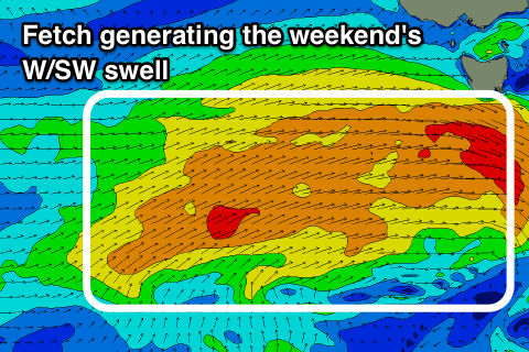
The swell will continue to fade through the rest of the week, but from the weekend we've got a more active and promising outlook.
A strengthening and stalling node of the Long Wave Trough across the south-east of the country will direct a relatively weak but slow moving polar front towards and across us from Wednesday through the weekend, followed by a possible secondary front early next week.
We'll see a fun mid-period W/SW swell generated by the first front, building Saturday afternoon and peaking Sunday. Clifton should build to 2ft later in the day and peak Sunday to 2ft to occasionally 3ft.
Winds look favourable each morning and out of the NW tending W/NW into Saturday afternoon but W/NW tending W/SW Sunday. A temporary drop in swell is likely Monday ahead of a new messier swell as the second front pushes up and across us Tuesday, but more on this Wednesday.