Lots of swell to come, large into the weekend

Southern Tasmania Surf Forecast by Craig Brokensha (issued Monday 29th October)
Best Days: Tuesday morning, Wednesday morning, Thursday, Saturday afternoon, Sunday
Recap
Tiny waves Saturday while an onshore change with a cold front pushing up past us brought with it a solid but bumpy 3ft of swell yesterday morning, easing back to the 2ft range today and still onshore with another system pushing through overnight.
Today’s Forecaster Notes are brought to you by Rip Curl
This week and weekend (Oct 30 – Nov 4)
A new SW groundswell due this afternoon, on top of the localised weaker swell should peak overnight, generated by a good polar fetch of strong to gale-force W/SW winds over the weekend.
This swell should ease back tomorrow from 2ft to maybe 3ft with cleaner conditions under a NW offshore ahead of SE sea breezes.
Our stronger W/SW groundswell for Wednesday has been downgraded a touch but is still looking good, with the low being a little tighter and smaller in scope compared to late last week.
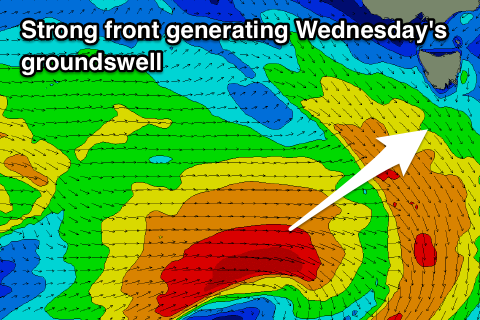 The low is currently south of WA generating a fetch of W'ly gales in our western swell window, and it will dip east-southeast and more into our south-western swell window this afternoon and evening while continuing to generate gale-force winds.
We should see the swell arrive through the morning, likely undersized at dawn and kicking to a strong 3ft through the day, if not for the odd bigger one and with NW winds ahead of sea breezes again.
The swell will ease off through Thursday from 2-3ft with N/NW tending N/NE winds, favouring more exposed breaks.
Into the weekend a strengthening front moving in from the west is expected to produce a fetch of severe-gale to storm-force W/SW-SW winds right under us Friday evening, producing a large SW groundswell for Saturday along with improving winds as another strong front approaches from the west.
Strong W/SW winds will swing W/NW into the afternoon as the swell builds to 4-5ft or so, clean and easing rapidly from 3-4ft Sunday morning with a NW tending variable breeze. The models are still moving around regarding this system though, so check back Wednesday for more detail about this swell and a follow up swell early next week.