Swell arriving and peaking later than you think

Southern Tasmania Surf Forecast by Craig Brokensha (issued Monday 16th July)
Best Days: Wednesday, Thursday, Friday morning, Saturday
Recap
A good new SW groundswell for Saturday morning but lumpy conditions under a variable wind from the east.
Sunday was much better with cleaner conditions and fun easing sets from the 2ft range, tiny into this morning.
Today’s Forecaster Notes are brought to you by Rip Curl
This week and weekend (Jul 14 - 20)
Want to receive an email when these Forecaster Notes are updated? Then log in here and update your preferences.
A slight lift in very inconsistent long-range groundswell may be seen through tomorrow, generated in our far swell window last week and only coming in at an infrequent 1-2ft.
Gusty N/NE winds will swing more N/NW into the afternoon creating improving conditions through the day.
We then look ahead to the moderate sized long-period W/SW groundswell due on Wednesday.
Over the weekend a severe low generated a storm-force fetch of W/SW winds on top a very large and active open ocean sea state, projecting on the edge of our swell window up towards the Bight.
The West Coast will see XXL surf, but with the super west direction, Clifton will see much smaller and less consistent set waves, building through Wednesday and peaking into the mid-late afternoon.
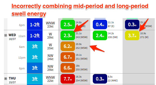
Our models are incorrectly combining this new long-period swell without much size early Wednesday with an existing W'ly mid-period swell and over-forecasting the size and bringing forward the peak.
This can be seen in the model guidance with 3.7m of mid-period 10.9s W swell at 12am/midnight Tuesday mixed with 2.3m of long-period 21.1s swell, incorrectly being combined Wednesday 6am, with it showing 6.2m at 20.9s. This is not the case with the long-period energy building through the day and peaking later more so rather than later.
Size wise i'm only expecting an inconsistent 3-4ft wave across Clifton into the late afternoon, 2ft to maybe 3ft during the morning.
Conditions will be great though with a fresh NW wind holding all day.
The swell is expected to start easing into Thursday from 3ft to maybe 4ft, but we've now got a secondary reinforcing W/SW swell on the cards for the afternoon, generated by a severe low firing up under WA tomorrow.
This low will generate a storm-force fetch of W'ly winds too north of our swell window, with it dipping east-southeast and more into our swell window on Wednesday.
Still it won't be greatly aligned with a fetch of W/NW gales being generated west-southwest of us.
As such I think we may only see 3ft of very west swell on Thursday afternoon, smaller into Friday morning and 2ft+. Persistent offshore NW winds will again keep Thursday clean all day, while into Friday an afternoon W/SW-SW change is expected as the frontal progression moves across us.
Some slightly better aligned W/SW swell is expected to fill in with this change, produced on the backside of the severe low.
A kick back to 3ft is due into the afternoon, easing from a similar size on Saturday morning as winds go back offshore from the NW.
Looking longer term there's nothing significant due until early-mid next week when another strong long-period W/SW groundswell is on the cards, but more on this Wednesday.