Tiny, windy conditions to persist for some time

Southern Tasmania Surf Forecast by Ben Matson (issued Thursday 28th June)
Best Days: No great days.
Recap: Tiny surf persisting.
Today’s Forecaster Notes are brought to you by Rip Curl
This week, this weekend and next week (Jun 29 onwards)
Want to receive an email when these Forecaster Notes are updated? Then log in here and update your preferences.
Note: Today’s Forecaster Notes will be brief, as Craig is away on annual leave. Also, these Forecaster Notes will be updated Tuesdays, Thursdays and Saturdays for the next few weeks.
Unfortunately our bleak outlook remains as it were a few days ago.
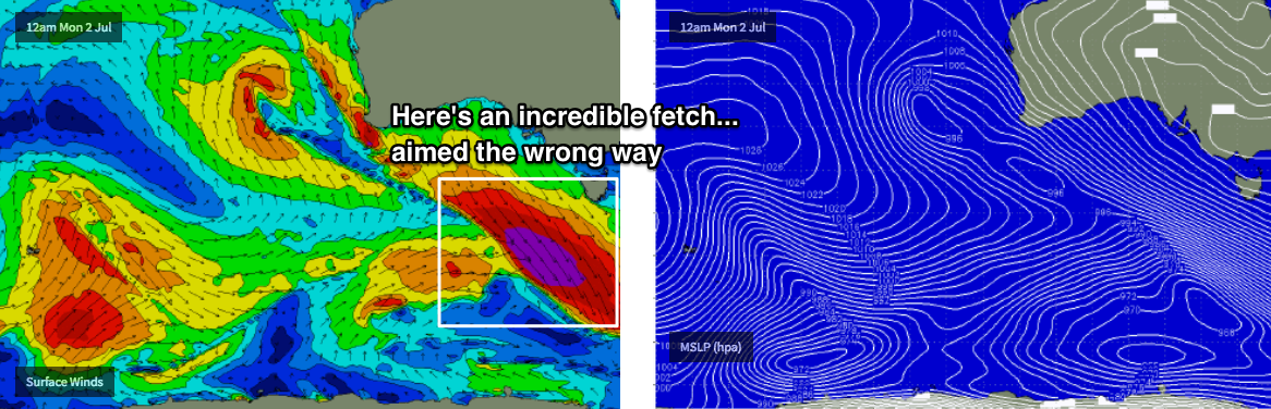
The Southern Ocean is active with a lot of vigorous weather systems but they’ve developed unusual alignments and as such our swell window is largely devoid of any significant, sustained pattern conducive for the kinds of large swells we require to get the South Arm up and running.
Just take a look at the 16 day forecast graph (here): it’s not estimating surf size any bigger than 1ft from now until next Friday (despite regional swell heights of up to 5m at times).
The extended wind outlook is a hint at the underlying synoptic problem - a couple of days of westerly gales, then a couple of days of north-westerly gales, followed by another spell of westerly gales. With not even a hint of south in the regional wind field, all incoming energy (the most significant being predominantly generated by pre-frontal activity) is simply headed away from our coast. And this local synoptic pattern is steering more distant weather systems outside of our swell window too.
We’ll see a few fleeting pulses of minor swells throughout this period (most interesting looks to be late Tues/Wed) but with these kinds of windy local conditions it’s going to be hard to muster up the enthusiasm to don the five mil, boots, gloves and hood.
Hopefully there’ll be something positive in the outlook when I update these notes on Saturday.
See you Thursday!