Good swell Wednesday, nothing thereafter

Southern Tasmania Surf Forecast by Craig Brokensha (issued Monday 15th January)
Best Days: Wednesday morning, Thursday morning
Recap
Tiny surf on Saturday while Sunday saw a pulse of new SW groundswell to 2ft with OK but not the greatest winds.
This morning we're back to smaller 1-2ft waves with an onshore wind. We should be seeing an increase in windswell from the front linked to today's onshore winds, reaching a messy 2ft+ across Clifton.
Today’s Forecaster Notes are brought to you by Rip Curl
This week and weekend (Jan 16 - 21)
The front responsible for today's increase in S/SW swell will linger enough to keep light onshore winds blowing across the South Arm tomorrow morning with easing 2ft sets.
We then look to the W/SW groundswell due Wednesday across the state, generated by a 'bombing low' east of Heard Island late last week and over the weekend.
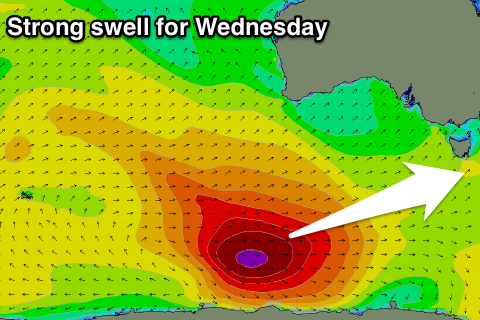 A fetch of severe-gale to storm-force W/NW winds were aimed through our swell window as the low moved east along the polar shelf while weakening.
A hint of new swell is due later tomorrow, ahead of a peak Wednesday morning to 3ft on the sets across Clifton with a morning NW breeze, giving into afternoon SE sea breezes.
The swell will ease into the afternoon, back further from 2ft on the sets Thursday morning with a light offshore wind again and afternoon sea breezes.
Unfortunately there's no new swell at all expected into the end of the week and weekend with the surf due to bottom out.
Into early next week there's also nothing major due besides tiny background W/SW energy, possibly slightly bigger later week, but more on this Wednesday.