Good waves Sunday and Wednesday

Southern Tasmania Surf Forecast by Craig Brokensha (issued Friday 12th January)
Best Days: Sunday, possibly dawn Monday, Wednesday
Recap
Tiny surf yesterday, with a slight lift in swell to waist high this morning with N/NE winds, favouring more exposed breaks.
Today’s Forecaster Notes are brought to you by Rip Curl
This week and weekend (Jan 13 - 19)
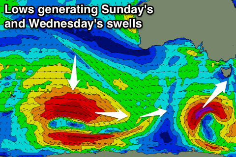
Today's tiny W/SW swell is expected to fade back through tomorrow and onshore W/SW-SW winds will be seen from a deepening and southward tracking low to our south-west.
This low will aim a tight but strong fetch of gale to severe-gale SW winds through our swell window this evening and tomorrow.
This will generate a good SW groundswell pulse for Sunday to 2ft to occasionally 3ft across Clifton. Winds should swing back to the W/NW with an approaching front creating clean conditions for most of the day.
 Monday will be smaller to 1-2ft or so with a possible early W/NW breeze, giving into an onshore change as a polar front pushes up past us.
This front will bring an increase in size to an average 2ft+ or so later in the day, easing back Tuesday from 2ft but with lingering onshore winds.
Of greater significance is the W/SW groundswell due off the 'bombing low' that's currently forming east of Heard Island.
The fetch around this low is looking very favourable for us, with severe-gale to storm-force W/NW winds being ideally placed in our great circle path.
As the slow moving low starts weakening it will push east helping keep wave heights up as the swell travels toward us.
A late increase in size is expected Tuesday, peaking Wednesday to a solid 3ft across Clifton. Conditions are looking great with a NW offshore, tending W/NW as a small tight low races in from the west.
We may see a spike in new SW swell late week from this low, but more on this Monday. Have a great weekend!