Small to tiny surf ahead of a better S'ly swell next week

Southern Tasmania Surf Forecast by Craig Brokensha (issued Wednesday 2nd August)
Best Days: Thursday, tiny waves Friday and Saturday, next week with the S'th swell
Recap
A drop in swell yesterday, while today some new W/SW energy was on the build, coming in at 1-2ft this morning. We should of seen the swell reaching a more solid 2ft during today but weak SE sea breezes.
This week and weekend (Aug 3 - 6)
Today's lift in W/SW swell will be reinforced by a secondary pulse tomorrow, generated by less than favourably aligned but strong pre-frontal W/NW gales moving in from the west.
We should see 2ft waves persisting most of the day, dropping back to 1-1.5ft Friday and Saturday morning. Winds tomorrow will be good for exposed breaks with a N/NW tending N/NE breeze and then N/NW tending fresher NE winds.
 The models are showing a new long-period swell for Saturday, but this was generated in our far far swell window south-east of South Africa and won't have any major size attached to it at all. We're more than likely to see easing sets from 1.5ft with a fresh NW breeze.
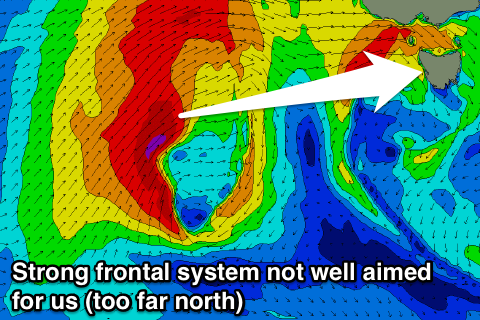
Also a strong polar front that was forecast to bring some new W/SW swell for Sunday now looks too push too far north and out of our swell window.
With this hardly any swell is expected to get into the South Arm, with it arriving overnight Sunday and peaking Monday. Only 1ft surf max is due.
Longer term the models have the tail of the polar front that will be north of our swell window will project a good fetch of S/SW gales up and into us Monday, generating a moderate sized S'ly swell for Tuesday and Wednesday, but more on this Friday.