Improving S'ly windswell late Wednesday, S/SW swell Saturday

Southern Tasmania Surf Forecast by Craig Brokensha (issued Monday 17th July)
Best Days: Late Wednesday, Saturday
Recap
A fun inconsistent W/SW groundswell Saturday to 2ft across Clifton with offshore winds, fading back to the tiny stuff yesterday and remaining so today.
This week and weekend (Jul 18 - 23)
The swell should remain tiny into tomorrow but as touched on in last week's updates, a broad mid-latitude low moving slowly east should cross us on Wednesday.
This will see a fetch of strong S'ly winds projected up into the South Arm, producing a burst of S'ly windswell to the 3ft range.
A secondary polar front firing up from our south-west will onshore SW winds back to the W/NW in the last hour or so of light Wednesday.
 Unfortunately this front looks to be too far west to generate any decent reinforcing swell for Thursday, and as this front moves east, winds will swing back onshore from the SW tending S/SE.
Some small S/SE windswell may be seen from this development, but with no major size and poor conditions.
Friday should become clean with the front moving further off to the east, but there'll be no size left.
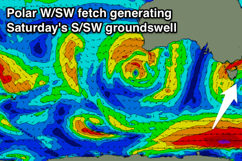
Into Saturday some new S/SW groundswell is due, generated by a strong polar front to our south-southwest Wednesday and Thursday, producing a stationary fetch of W/SW gales.
No major size is expected but we should see 2ft sets Saturday, fading into Sunday. Conditions look clean as well all day Saturday with NW tending SW winds Sunday.
Longer term there's nothing major due with continued mid-latitude storm activity, but more on this Wednesday.