Building surf, generally from a range of ordinary sources

South-east Queensland and Northern NSW Surf Forecast by Ben Matson (issued Mon 20th Feb)
Forecast Summary (tl;dr)
- Several low/mid period E'ly swell sources contributing OK peaky beachies for the rest of this week
- Onshore winds in general though Tues/Wed AM should see workable conditions
- Most coasts becoming wind affected later Wed/Thurs/Fri
- Long period S'ly swell across Northern NSW from late Tues into Wed, though expect large variations in size across the region
- Small easing mix of swells this weekend
- Tropics looking good long term, though worthwhile options keep geting pushed back in the timeline
Recap
Small SE swells provided 2ft+ sets across Northern NSW on Saturday (super fun open beaches with light winds), though SE Qld didn't pick up anywhere near as much size, and wave heights eased a little into Sunday. Today is smaller with nothing really on offer for surfers.
This week (Feb 21 - 24)
(apologies this is late - and slightly rushed - Steve was covering the WSL today and I'm on the road)
We've got some waves on the way, but conditions are looking a little average to be honest. There'll be waves but it won't be epic.
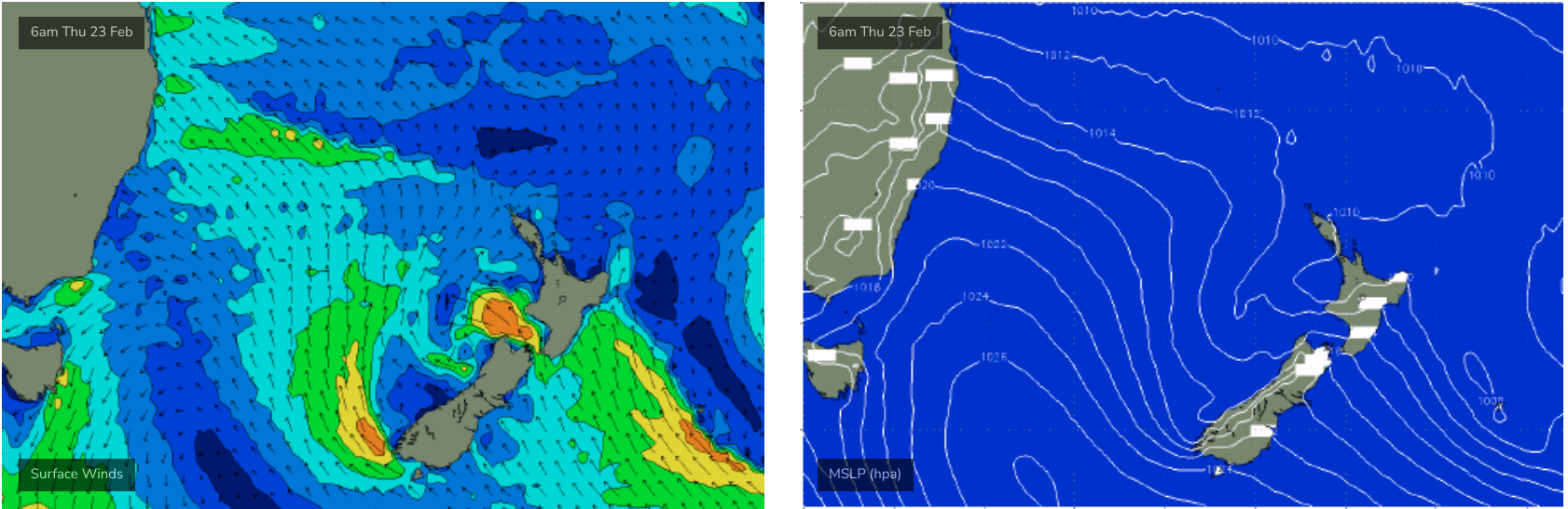
Although there are far more synoptically interesting swell sources on the cards, the main swell source for SE Qld and Far Northern NSW this week will be a building ridge through the Northern Tasman and Coral Sea that's expected to generate a couple of days of 2-3ft surf from later Tuesday through Wednesday before easing slowly into Thursday.
Interestingly, the main ridge will break down Tuesday morning (though there's a 24-36 hour time lag on the associated swell trend) however we'll see an active fetch remain at the tail end of the ridge (i.e. NE of New Zealand) along with a new coastal feature. They'll both contribute small levels of swell into the remainder of the forecast period.
Nore notably, an unrelated ridge moving northwards through the Tasman Sea mid-week will supply new energy through the second half of the week, which should push a little higher across exposed south facing locations (read: south of the border) - though they'll be wind affected.
So, expect small semi-exposed SE Qld points to offer lil' sliders for the next few days though the swell direction will veer more S/SE later in the week which may slightly restrain options north of the border.
Also in the mix this week is an unusual long period southerly swell expected to glance the Northern NSW coast later Tuesday (MNC) and Northern Rivers (Wednesday). Local winds won't be great, and the swell will only fabvour a handful of reliable south swell magnets, but we may see one or two spots light up with inconsistent 4-5ft sets.
Winds will hold from the eastern quadrant (possibly NE at times on the MNC) for the next few days ahead of a gusty S/SE change spreading along the coast later Wednesday.
As such, keep your expectations low, but there will be waves around.
This weekend (Feb 25 - 26)
Slowly easing swells are expected this weekend, from the same sources mentioned above plus a small SE swell from a small low developing off the SW tip of New Zealand later Wednesday and into Thursday (see below). This will really only favour Northern NSW with some 2-3ft sets on Saturday morning, but every little bit helps when the charts are needing some assistance.
A slight drop in size is expected on Sunday though there'll still be fun beachies around the traps.
Early mornings look to offer the best waves with light winds.
Next week (Feb 27 onwards)
Last Friday's notes mentioned some opportunities for the long term from the tropics. The potential is still there but the models have shunted developments back a couple of days, which is concerning as it sometimes takes a week or two for the pattern to lock into the window (what I mean is, I wouldn't be surprised if it's shunted back again tomorrow and Wednesday).
Either way, the models aren't showing anthing definitive but there are options brewing long term so let's see how Wednesday's outlook is performing.
Comments
has there been a downgrade in the longer term forecast?