Not much the next few days but a lully S swell for the weekend
South-east Queensland and Northern NSW Surf Forecast by James Casey (issued Wednesday 23rd June)
Outlook (tl;dr)
- Not much for the end of the week with N winds and an easing SE swell combining with a weak NE windswell
- On Saturday afternoon a long period, inconsistent S swell will arrive but will be best south of Byron. It'll be slow so it's best left for the patient on Saturday, a little more consistent for Sunday into Monday
- Stronger better aimed S swell for Tuesday/Wednesday up around 5-6ft for S swell magnets, easing into Thursday. Don't get excited SE Qld it won't be more than 2ft for you
- Reinforcing SE swell for Friday, better aimed for SE Qld
- More E swell action brewing further down the track, far better prospect for SE Qld
Recap
Yesterday we saw a bit more size with 2ft waves at the exposed northern ends of beaches. Unfortunately these spots picking up the most of the size are a little bumpy due to the S winds. Southern corners were smaller but cleaner
South of the border waves were up around the 4ft mark yesterday but with S winds again you had to stick to southern corners for cleaner conditions where it was a little smaller.
Today we have 2ft waves out of the S/SE with light S to SW winds. South of the border there is a little less energy than yesterday but still 3-4ft with light offshore winds.
The rest of this week
Later today (Wednesday) you can expect winds to swing around to the NE as a mid latitude low approaches from the west. Winds north of Coffs to the south of Byron look to remain light and variable for most of the day while elsewhere looks bumpy with NE winds. Northern corners will be your best bet to make the most of the SE swell and NE winds this afternoon.
These N/NE winds will continue for the next couple of days out to sea creating a small 1-2ft windswell for tomorrow (Thursday), while fairly soft there will still be some easing SE swell that'll pack a bit more punch.
Tomorrow will see winds light and out of the NW early in the morning tending more N as the day goes on.
On Friday the region of low pressure will move offshore allowing winds to swing around to the NW for the rest of the day. Unfortunately there will only be 1-2ft of NE windswell on offer and less of the SE swell so there won’t be a lot on offer.
The weekend
This weekend isn’t looking great for SE Qld but south of the border, more specifically south of Byron, there will be some inconsistent S swells for both Saturday and Sunday. 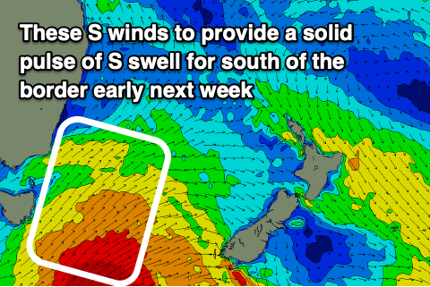
Winds will shift around to the SW on Saturday morning becoming light and variable out of the W/SW south of the border into the afternoon. For SE Qld winds will remain fresh out of the S/SE into the afternoon.
The inconsistent, long period S swell will fill in on Saturday. It’s not going to be anything special, just a lully 2-3ft best for the patient. This swell will originate deep in the Southern Ocean travelling from beneath Tassie to reach our coast.
On Sunday we will see the sets become a bit more consistent as the longer period S energy from the Southern Ocean is better aimed and the fetch being closer. A local S swell will also fill in for the afternoon, filling in the gaps between sets thanks to a burst of winds out of the eastern Bass Strait and S winds moving up the coast. It’ll be a similar size to Saturday just more consistent, 2-3ft for S swell magnets. Winds will be SW early but tend more SE into the afternoon meaning you will need to stick to southern corners for most of the day.
For SE Qld there won’t be much swell energy from the S as the acute angle struggles to bend around the corner. Instead there will be a weak E/NE windswell around the 1-2ft mark preventing it from being completely flat.
Next week
Monday will see SW winds early but stronger winds out of the S will build into the afternoon. Tuesday will see winds SW early but they will swing around to the E/SE by the afternoon. Wednesday isn’t looking much better with light S winds early tending E and strengthening into the afternoon. Southern corners for Monday and Tuesday and then not many options on Wednesday will mean there won’t be too many quality options.
Swell wise we will see a bit of windswell build before a stronger pulse of S energy arrives for the MNC on Tuesday morning, N NSW Tuesday afternoon and SE Qld late Tuesday/ early Wednesday. This pulse of S swell will see waves reach 5-6ft for S swell magnets south of the border.
For SE Qld I wouldn’t expect more than 2ft sets at the south swell magnets as most of the swell fails to wrap in. There’ll be a bit of E/SE energy from local winds but nothing exciting and mainly in that 1-2ft mark.
On Friday we may see a reinforcing S/SE groundswell from the severe gales associated with the backside of the front that brought Tuesday's swell. This fetch to the south of NZ will bend in towards our coast thanks to the great circle path. It’ll be worth keeping an eye on especially for south of the border, not so much for SE Qld.
Further ahead there looks to be a fun looking E swell developing that’ll deliver a far more even spread of waves across the region. Even further down the track there looks to be a distant yet powerful E/SE swell from a low but the timing and size will become clearer the closer we get to it. Tune in on Friday for an update.
Comments
The shit month of June continues...
Nice report James.
Yes, I agree,
Agree also. Nice to know predicted height range for Sunshine Coast.
northerlies in june ...mmm....
Nice little window this morning of fuk all