S swells replace the run of E swell
South-east Queensland and Northern NSW Surf Forecast by James Casey (issued Friday 14th May)
Best Days: S swells best south of the border. Peaking Sunday and then again on Tuesday/Wednesday
Outlook:
- Smallest it’s been for a while tomorrow (Saturday) as E swell fades
- 3-4ft S swell to fill in late Saturday into Sunday with offshore winds continuing
- Winds go more out of the S at the start of the new week with a larger S swell set to peak around 4-6ft (south of border) on Tuesday into Wednesday.
- Swell to fade into Thursday
- Another S swell looks to fill in for the weekend
Recap
Yesterday we saw a little spike in the swell up to 3-4ft with winds light and offshore. The afternoon saw a light onshore breeze creating a bit of bump late rin the day.
Today we had 2-3ft waves across the region with winds remaining offshore all day for SE QLD, a little onshore breeze south of the border.
All in all it’s been a good time for waves, a truly magical May so far.
The weekend
The E swell will fade into Saturday, not offering up much more than 2ft waves, as a S swell starts to gain some momentum south of the border. By the late afternoon the MNC and N NSW will see some larger sets out of the south. This swell will be generated by winds around the western flank of a trough and associated low as it moves around Tassie and up the East Coast.
By Sunday the S swell will have arrived for the MNC but will fill in throughout the day for N NSW, peaking up around 3-4ft. Due to the acute angle of the swell direction there won’t be much of a change in wave heights for most of SE QLD. Just the more S facing beaches will see a small bump up in size.
Winds will be out of the W/SW for most of Saturday turning light and onshore in the afternoon. For Sunday, winds will be stronger out of the S/SE although there’ll be SW winds early.
Next week
Offshore winds will return for the start of next week under a ridge of high pressure although a S change will make its way up the coast with the MNC getting windy by the afternoon, N NSW by the early evening and SE QLD overnight. These S/SE winds will continue into Thursday with SW winds early each morning providing cleaner conditions. South of the border will see lighter and more variable winds in the afternoon. 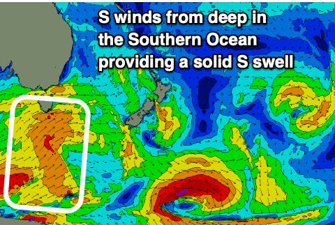
Waves will ease on Monday before a larger S swell arrives for Tuesday and holds into Wednesday. Expect waves up around 4-6ft for N NSW and the MNC on Tuesday and Wednesday while SE QLD will again miss out on most of the action as it fails to wrap around the corner, mainly relying on what is left out of E swell.
This swell will form with a cold front in the Southern Ocean over the weekend, in NSW’s acute south swell window. It’ll travel a fair distance but with strong winds accompanying the front it won’t be too slow. The longer period energy will fill in on Wednesday afternoon and continue into Thursday so expect a bit more push but longer waits between the sets.
The swell will slowly fade into Thursday before another cold front moves through for the end of the week and into the weekend but more on that in Monday’s update.