Lots of south swell this week, before a return to the east

South-east Queensland and Northern NSW Surf Forecast by Ben Matson (issued Monday 23rd March)
Best Days: Fun S'ly swell Wednesday (Northern NSW) with improving conditions. Another on Friday too. Saturday, Sunday and Monday are all lining up for good E'ly swells across all coasts (winds pending).
Recap: Easing E’ly swells on Saturday still offered some good beachbreaks around the 2-3ft mark early on, with light morning winds keeping conditions clean. A S’ly change pushed up the coast during the day though it wasn’t too strong. Sunday dawned clean with light winds ahead of an afternoon sea breeze, and a new S’ly groundswell increased wave heights into the 3-5ft range across south facing beaches south of Byron, though very little of this swell made it north of the border. Sets were extremely inconsistent too. Surf size has eased back this morning ahead of a redeveloping S’ly flow and a building S’ly swell into the afternoon.
This week (Mar 24 - 27)
Today’s S’ly change will build a ridge across Southern Queensland on Tuesday, generating some small S/SE swell for SE Qld and Far Northern NSW. However, winds will be mainly fresh SE so conditions won’t be great at most beaches, only sheltered points will offer anything worthwhile - and they’ll be smaller.
The Sunshine Coast's open beaches will pick up the most size from this source with occasional 2-3ft sets by the afternoon, and surf size will become a little smaller as you track south from the Gold Coast. Don't expect any quality though.
This change is also linked to a strong front pushing through the Tasman Sea today, which is generating a small to moderate S’ly swell that’ll offer 3-4ft sets at south facing beaches (south of Byron). Surface conditions will be wind affected north from Coffs under the SE breeze (strongest in the north), but south from here we may see a reasonable period of light variable winds through the morning.
In addition to this, a new long period south swell will push across the Mid North Coast from about lunchtime onwards, probably reaching the Far North Coast very late in the day (too late to benefit the surf). This swell was generated by a strong polar front/low that tracked well south of Tasmania over the weekend.
Wind speeds were a touch below model forecasts but the fetch was very broad in coverage, so at this stage I don’t have any major reason to downgrade the outlook of the last week or so.
And that is for south facing beaches south of Byron should reach a peak around 4-5ft+, probably very late Tuesday on the Mid North Coast and early Wednesday across the Far North Coast (by which time the swell will be easing steadily form the south). For what it's worth, I suspect buoy data will show an overnight peak in size, but I still think we’ll see some solid waves across exposed regions either side.
Unfortunately, I don’t expect much of this south swell to penetrate north of the border, only exposed northern ends of the Gold Coast may pick up occasional 2-3ft sets early Wednesday at best.
Wednesday’s conditions look OK with light winds, generally onshore but without any major strength. We’ll also see a small lingering SE swell from the ridge across the northern Tasman Sea, perhaps some early 2ft, maybe 2-3ft sets on the Sunshine Coast’s open beaches but easing through the day, and smaller south from the Gold Coast.
The rest of the week continues the southerly swell theme. A weak ridge through the Northern Tasman Sea and Coral Sea will maintain slow E’ly swells across SE Qld, probably 1-2ft at most beaches tops. Early light winds will veer moderate S/SE through the days.
Our southern swell prospects will be tempered - on the Mid North Coast at least - but a fresh S’ly change on Thursday. It’s due into the Lower MNC Thursday morning, reaching Coffs by lunchtime though may not push much further north than Yamba into the afternoon.
Surf wise, a bigger S’ly swell from the parent low/front associated with this change will kick up 3-4ft+ surf at south facing beaches into Thursday afternoon, and perhaps Friday morning, before easing during the day. Anywhere not open to the south will be smaller and once again I’m not expecting much size north of the border.
As a side note, the early incarnation of the primary low associated with this front (for Thursday's S'ly swell) is currently well below WA, and it's really strong - but positioned right on the northern periphery of our acute south swell window. Wind speeds have been really strong around the low but I fear most of the generated energy will bypass our coast (that being said, if we see longer-than-expected swell periods and a couple of bigger clean up sets at south swell magnets, this is where it will have originated from).
Thursday should have workable options north of Yamba with generally light winds, and Friday morning should continue this favourable theme almost everywhere before a redeveloping coastal ridge freshens SE winds across all areas into the afternoon.
This weekend (May 28 - 29)
The weekend looks a bit tricky, but there is certainly some potential for good waves as our eastern swell window lights up again.
A rebuilding ridge through the Northern Tasman Sea is expected to build E’ly swells across all coasts, from 2-3ft to 3-4ft during Saturday, and maybe a little higher on Sunday at exposed spots (say, 3-5ft). As always, surf size will be smaller running down the points.
In general, the models are suggesting a mainly onshore airstream associated with this pattern but a weak coastal trough may provide just enough buffer to allow for locally light variable winds - for Saturday at least. Sunday has this potential too but we are more likely to see the ridge push back on to the coast at some point.
Let’s take a closer look on Wednesday.
Next week (May 30 onwards)
A stationary trade flow through the Tasman Sea will provide plenty of E’ly swell for our region early next week though surf size will probably ease back from the weekend peak. However, there’s a suggestion for an enhanced E’ly flow to develop north of New Zealand next weekend, providing a mid-late week kick in larger surf. Let’s check back on Wednesday to see how that is tracking.
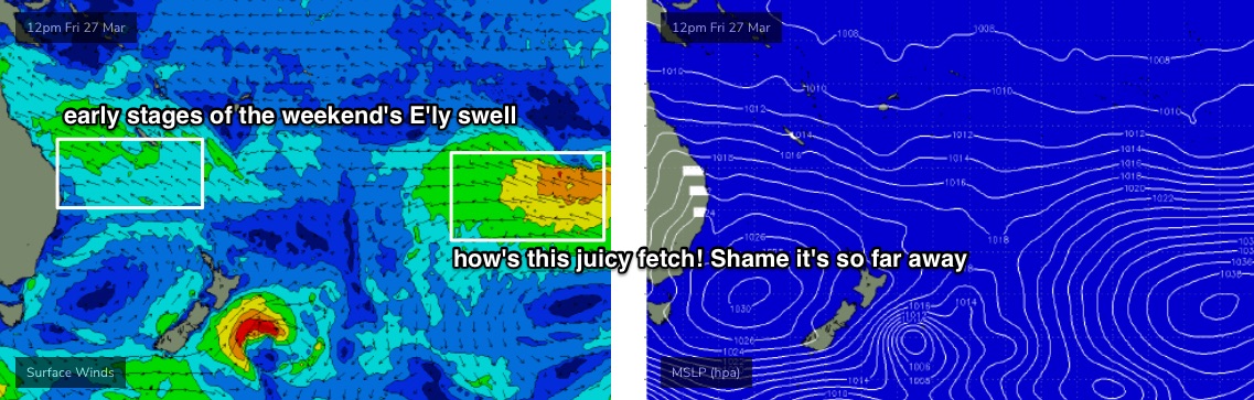
There's also a nice though extremely distant source of E'ly swell developing in the Far South Pacific over the next few days (see below) that'll provide some small long range E’ly swell during the middle of next week. Ordinarily it wouldn't be worth reporting unless all of our other swell windows become inactive, but I'll keep a watch on it anyway.
See you Wednesday!
Comments
Hey Swellnet,
What's the story with the daily surf report for the Sunshine Coast? For way too long now the "updated report after 8am" is nothing more than a story from the "reporter" about the surf session he just had, usually posted about 11 am if there has been any surf. (See today's for a prime example).
Now I know if you take the literal meaning of the word "report", then ok, this is what he is doing, but I think it's a pretty well established principal that a surf report is supposed to be information about what to expect the surf to be like for the upcoming day.
It's been the same story for months, probably years, but as a paying subscriber, I would expect to get the advertised daily report at 8am.
For the Sunshine Coast, there is currently a far more accurate observed forecast on your competitor's site, for free, at daylight most days.
Might be time for a quiet word to your man, or find someone else.
agree!
Agree as well.
Loves an overblown score too lol.
That South end CW one is wrong most of the time for anywhere outside his local. It's quite obvious the forecasters who only check their spot and have no idea what conditions work at other spots, or report from their bed looking at wind/swell charts.
I agree. Mark's a nice guy, but we pay for updated and on time reports.
Ha I don’t live there but couldn’t help but take a look After these comments and todays early report said 3/10 then he comes in late bragging about a 10/10 session but it’s now onshore. Maybe a quick update before you paddle out next time fella. Oh well I just use cameras myself....and gut instinct
After these comments and todays early report said 3/10 then he comes in late bragging about a 10/10 session but it’s now onshore.
lol, dogging the boys!
Agree as well, and drives me nuts that Moffats is still a cam choice (not that I surf there) when it has literally been down for years
Point taken re: surf reports upload times. It's a rightful kick up the bum to sort this out. I'll pass on the feedback.
Truth be told, we've had a major 'surf report' overhaul in the works for a while but have been trying to knock off a couple of other projects first. I'll see what we can do to prioritise things.
Border closures = less crowds?
Personally I like Marks reports and I am paid subscriber living on the sunshine coast
Always gives me a smile
Yep ill second that.
Marks alright.
His observations are made from the center of the sunny coast.
Its quite easy to join the dots and work out for yourself exactly whats happening a few Ks up and down the coast.
Phantom quiky pro forecast in tomorrow's notes? The automated model is showing what would've been fun competitive conditions.
Detailed forecast notes, 16 day forecasts, WAM’s and cams. Buoy and wind data elsewhere.
Who’s waiting around for a subjective report from someone you don’t know , that’s not at your beach before deciding where to surf?
ahah so true
Anyone noticed a big uptick in crowds the last 4 days, especially given the conditions? I think there's some panic surfing going around in these parts(Gold Coast).
Unemployed and out of schoolers
Don....tell me you weren’t still holding BOT.
Was one set bombs this morning much bigger and way more powerful than the underlying smaller swell. But weird they were only one wave wonders.