Lengthy run of easterly swell ahead

South-east Queensland and Northern NSW Surf Forecast by Ben Matson (issued Friday 10th January)
Best Days: Tricky options over the weekend with mainly small swells and windy periods at times (though, there'll be waves). Large S'ly swell for Northern NSW Mon, easing Tues, then an extended period of E'ly trade swell for the following week, maybe longer. Just like the good ol' days.
Recap: Small leftovers for the last few days, up to 2ft at south friendly beaches south of Byron and mainly light winds with sea breezes. Smaller in SE Qld.

Coupla little waves at D'Bah this morning
This weekend (Jan 11 - 12)
Saturday looks tricky.
An approaching southerly change will freshen winds from the north across most regions, before the change reaches the Lower Mid North Coast early morning, then meanders slowly north to be near the Northern Rivers late in the day.
This will probably keep winds out of the northern quadrant across SE Qld all day though they should ease gradually from lunchtime onwards. Elsewhere, we’ll see a period of light winds ahead of the S'ly change, which could become quite gusty at times into the afternoon.
As for surf, there’ll be a mix of swells in the water - a small building trade swell across SE Qld and Far Northern NSW's exposed beaches (slow, lacklustre 2ft+ sets), an initial peak in short range N/NE swell across the Mid North Coast (3ft+ early, easing during the day) and then a return S’ly windswell throughout Northern NSW - mainly south from Coffs - in the wake of the change. This last swell will be heavily wind affected and won’t get into protected spots due to the low period, so don’t expect amazing surf.
Overall, there’ll be small windows of opportunity on Saturday but you’ll need to be keen and flexible.
Sunday is a much different proposition.
The S’ly change will push into SE Qld with vigour during the morning (an early variable period around dawn is possible on the Gold Coast and probable on the Sunshine Coast), and fresh S/SE winds will dominate the rest of the day.
We’ll see building S/SE swells across the region, reaching a choppy 4ft at south facing beaches in Far Northern NSW by the afternoon, but it’ll be smaller across the Mid North Coast and into SE Qld where the less favourable coastal alignment will restrict the bigger sets to exposed northern ends (and they’ll be wind affected).
There will also be a small peaky trade swell in the mix, so early morning has beach break potential in SE Qld ahead of the change. You’ll want to be quick though.
Once the wind kicks in, you’ll need to look for some protection and late afternoon should see 2-3ft sets at the outer points (it’ll be too small for inner points).
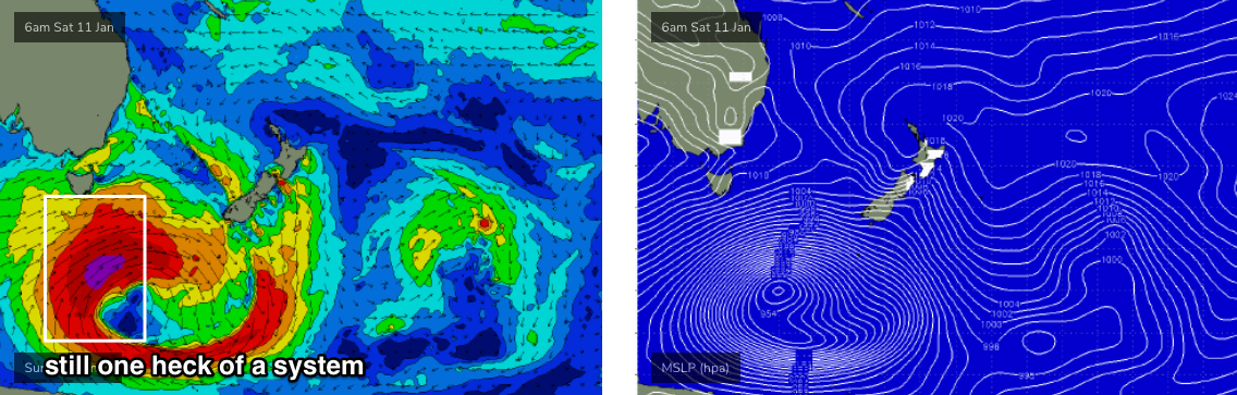
Very late in the day may see new long period S’ly swell reaching the Lower Mid North Coast, sourced from from the parent mid-latitude low (to the weekend’s S’ly change) that’s expected to ‘bomb’ south of Tasmania over the weekend. Most of the swell from this low is due to arrive on Monday, but south facing locations south of Coffs (more likely south of Port Mac) could pick up some 4-5ft bombs. However conditions won't be great, so it'll only be surfable at protected southern ends.
Next week (Jan 13 onwards)
The models have slightly wound back the strength of the bombing low below Tasmania (see below), though they’re also suggesting a minor slingshot during its initial stages. On the balance, I’ve fractionally pulled back surf size estimates from Wednesday’s notes, but we’re still looking at a very large, significant southerly groundswell event throughout Northern NSW to kick off the working week.
Most south facing beaches south of Byron should hold easy 6ft+ sets through Monday, with occasional bigger sets at one or two of the more reliable south swell magnets.
Elsewhere, we’ll see much smaller surf - including SE Qld - but there’ll be an underlying level of short to mid-range trade swell and S/SE swell from Sunday’s change. Expect slow, peaky 2ft to nearly 2-3ft sets across the outer SE Qld points, with bigger surf at exposed northern ends pushing 4ft+, though very wind affected.
Monday’s S’ly swell will then ease from Tuesday onwards, and we’re looking at an extended run of E’ly swell as the trades firm up and broaden through the swell window. One of the active ingredients is an approaching Tropical Cyclone that will develop around Vanuatu and move southwards, ridging up against a high pressure system in the Tasman Sea.
Surf size should build into the 4ft range throughout SE Qld and Far Northern NSW by Wednesday (slightly smaller south from Yamba), and persist in and around this size for the rest of the week, the following weekend and probably the first half of the next week - thanks to a broad, persistent high pressure system north-west and north-east of New Zealand, cradling a large area of low pressure throughout the Tropical South Pacific.
But of course, we’re all more interested in what this Tropical Cyclone might do.
Over the last few days, the models have formed a more credible consensus that there WILL be a Tropical Cyclone event (ECMWF was an outlier until today). But while confidence is high on the probability of a TC, that doesn’t necessarily translate to a significant cyclone swell event.
At the moment, I suspect the supporting ridge to the south and south-east will probably be a more dominant source, providing most of the surf mentioned above, though there is certainly the chance that we’ll see the odd bigger set sourced from the cyclone itself (probably later next weekend or early in the following week). But right now, the relatively small (forecast) size of the cyclone and its modelled path doesn’t suggest any major size out from this specific weather system.
Nevertheless, I’ll keep an eye on this and will update over the weekend if things upgrade.
Have a great weekend!
Comments
Thanks Ben. Yet another set of great notes.
Fair dinkum, my Swellnet subscription is the best $80 I ever spent. Quality information presented succinctly and always entertaining.
Dave
Seconded
Thirded
Fourthed
Great notes as always Ben. FFS though, for the southern Goldie it reads flat and onshore Sat. Flat and offshore Sunday. Situation normal for the last god-knows-how-long...
Be patient. There’s been a considerable shift in the weather pattern this week and a more typical summer pattern now looks likely for at least the next week plus plus. So those who wait with patience will be rewarded.
Good weekend outlook for the Single Fin contest at Burleigh...
Damn that just kinda makes you feel good, cheers Ben!!
sgig ban dres ma defr criwa
sure the forecast notes were good but I haven't paid tax all last year...
can predict the waves= pumping 3ft noosa with 150 people fighting for crumbs
15 angry c""ts in the spot eyelling go go go! for when a closeout comes. Harry Bryant, show me your ways, ya legend. Most underated surfer here I reckon. Some people probably hate. Hate on jules as well. No locals at noosa cause it breaks 15 times a year, but everybody thinkd they own the waves. Everybody chills and believes in kindness= everybody who can surf gets waves. I'll be the guy going yeeew for when anybody gets good waves, (especially harry who just sends it to the postman and gets a letter back from the queen) on a board given to me by a guy I don't know, on some pre-war era board. Peace.
Maniac
Lay off the mushy omletes dude... peace out.
https://images.app.goo.gl/KJVomx85vWNjEMZj6
Fcking Fck Fck looks like we won’t over the Fcking Nlys just yet!!!
Couple of days of southerlies to get us excited, then back to that northerly flow. Cyclone swell number two, ruined by the devil winds. Over it.
easterly swell northerly winds.. finally good conditions for sunny coast.
Too early to be overly concerned I reckon. There were good waves during the last event (despite the broader N'ly forecast), and there'll be plenty of good waves during this next spell. May have to be a little more creative, but hey! There'll be waves.
Cold water upwelling seaweed. Strong Ely swell and Nly winds. Doesn’t make for overly appealing conditions IMO. Beachie Banks aren’t primed for anything north of east in the swell either. They love anything south of east. Straighthanders pretty much the entire last swell event.
Big call on ‘the beachies’ not being able to handle anything north of east.
Not sure what beach breaks you’re referring to.
Sand was primed at my spot and it loves an ENE swell, this particular one was just too long period and lined up to be any good. In saying that we got a few barrels and I know of beachies that we’re quite good. Sand wasn’t the issue.
Interesting lineup shots on the Yamba report this morning....
Haha, you can’t have three ladies and keep it quiet now, can you?
Nav you ol fox
Is that Gary G?
@thermalben are we going to see any swell tomorrow or Tuesday on the MNC? The period looks interesting?
Only 2-3ft of choppy wind swell at a Sth magnet so far this morn.
Bit more yesterday arvo/eve
Really LD? It's bigger than that at D'Bah.

And although only small in size, these peelers running down The Pass look much better quality than a windswell (they're nicely defined).
Weird too, I surfed locally yesterday early afternoon and the swell seemed to be dropping (though I think the dropping tide wasn't helping). Shortly after I came in, a scan of the Goldy surfcams and a squiz at the buoy data suggested the surf had actually lifted - much different to what I'd seen in the water for the previous 90 mins.
Still at the lookout, and there might have been the very odd 4ft peak but only at the very peak of the wave then it breaks in to mush.
This is one of the magnets that usually performs better in these swells than your calls too.
Also worth pointing out (I've mentioned this in the Sydney notes) that the S'ly groundswell is running behind schedule today. However, Sydney's south facing beaches have built from 3-5ft at dawn to now 6ft or so, which is inline with size expectations. So we can expect a solid increase through the day (mainly the afternoon) across Northern NSW.
Apart from the sand being abit funky at the local point still picked up a few nice wide ones from the swell direction.
Thanks for the reports Ben!