Average conditions, but a couple of swell sources on tap

South-east Queensland and Northern NSW Surf Forecast by Ben Matson (issued Wednesday 30th October)
Best Days: No great days due to local winds, but we've got some fun trade swell ahead for SE Qld, peaking over the weekend.
Recap: Northern NSW has picked up plenty of south swell over the last few days, with intermittent sets around 3ft+ at south swell magnets. Surf size has however been smaller elsewhere, and apart from a small SE windswell yesterday, SE Qld hasn’t seen much surf. Morning winds have been light south from Ballina, with freshening afternoon sea breezes from the north-east. Winds have been more SE tending E’ly in SE Qld and Far Northern NSW, tending NE today.
This week (Oct 31 - Nov 1)
N/NE winds will remain the dominant influence on Northern NSW’s surf prospects for the next five days.
Wind strengths will be greatest along the Mid North Coast, with moderate NE winds in Far Northern NSW and light to moderate E/NE tending NE winds in SE Qld. We’ll probably see periods of variable winds early morning, but this will be confined to a handful of coasts mainly north from Byron Bay.
As for surf, the Southern Ocean is still directing southerly energy through the Tasman Sea but it’s all a little more off-axis than the swells that provided fun waves for the first half of this week. There’s still a few minor swell fronts expected to glance the coast but in general the rest of the week will probably see smaller, very inconsistent wave heights at south facing beaches, maybe 2-3ft early Thursday but easing to 1-2ft by the afternoon and into Friday. It's not worth getting too excited about.
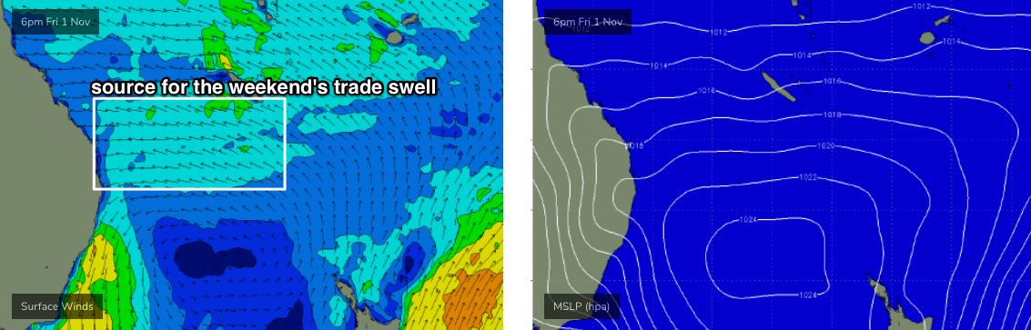
Fortunately, we also have a building trade swell on the cards, thanks to a developing E’ly flow in the lower Coral Sea.
Thursday will start off small, around 1ft+ at exposed beaches, building to 2ft+ during the afternoon and then 2-3ft on Friday. Please note: the upper end of this size range is more likely on the Sunshine Coast, and we’ll see incrementally smaller surf as you head south from the Gold Coast.
Of course, winds won’t be perfect but given the lacklustre period of Queensland surf it’s well worth looking at getting wet as this trade swell builds towards a weekend peak.
This weekend (Nov 2 - 3)
The south swell will be all but gone over the weekend, and northerly winds will really create tricky surf prospects for the Mid North Coast. We’ll see small levels of trade swell here but only protected northern corners will be clean, and they’ll be pretty small.
There’ll be a local N/NE windswell in the water too but quality won’t be high (maybe some 2-3ft sets from this source both days).
Size potential from the better-quality trade swell is higher with increasing northerly latitude and therefore SE Qld is looking at some fun surf this weekend, though local winds will certainly take the sheen off things. There’s a chance for isolated pockets of variable winds, but in general expect moderate NE winds for the most part, tending N/NE on Sunday.
The Sunny Coast will see the most size, peaking around 2-3ft+ Saturday, easing back a touch into Sunday, and wave heights will become gradually smaller as you head south from the Gold Coast.
Keep your expectations low, and you’ll do OK this weekend.
Next week (Nov 4 onwards)
An advancing trough will maintain northerly winds through Monday, before pushing a southerly change across the Northern NSW coast during Tuesday, reaching SE Qld very late in the day.
The weekend’s trade swells will ease slowly through this period, so expect a slightly smaller version of Sunday on Monday.
Tuesday’s southerly change won’t have much of a trailing fetch. The models have a loose consensus that a weak low may form off the Central NSW Coast during Monday in association with the trough, but they then scoot it away to the NE, so I’m not expecting much surf from this system, maybe a small S/SE windswell at exposed south facing beaches south of Ballina.
Otherwise, a series of poorly aligned fronts will then track south of Tasmania, supplying southerly swell across Northern NSW for the rest of the week.
The first fronts look rather unimpressive but a strong system later Tuesday is on track to provide some interesting long period though very directional south swell around Thursday. Let's ballpark south facing beaches in the 3-4ft+ range at this stage.
More on this in Friday’s update.